You are here: Home > Network List > CI - Caltech Regional Seismic Network Stations List
> Station BBR Big Bear Solar Observatory > Earthquake Result Viewer
BBR Big Bear Solar Observatory - Earthquake Result Viewer
| Earthquake location: |
Peru-Brazil Border Region |
| Earthquake latitude/longitude: |
-7.6/-74.5 |
| Earthquake time(UTC): |
2011/08/24 (236) 17:46:11 GMT |
| Earthquake Depth: |
147 km |
| Earthquake Magnitude: |
6.8 MB, 7.0 MW, 7.0 MW |
| Earthquake Catalog/Contributor: |
WHDF/NEIC |
|
| Network: |
CI Caltech Regional Seismic Network |
| Station: |
BBR Big Bear Solar Observatory |
| Lat/Lon: |
34.26 N/116.92 W |
| Elevation: |
2069 m |
|
| Distance: |
57.8 deg |
| Az: |
318.729 deg |
| Baz: |
127.865 deg |
| Ray Param: |
0.06277244 |
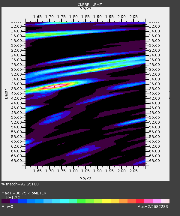
| Estimated Moho Depth: |
36.75 km |
| Estimated Crust Vp/Vs: |
1.72 |
| Assumed Crust Vp: |
6.276 km/s |
| Estimated Crust Vs: |
3.649 km/s |
| Estimated Crust Poisson's Ratio: |
0.24 |
|
| Radial Match: |
92.65188 % |
| Radial Bump: |
400 |
| Transverse Match: |
82.10724 % |
| Transverse Bump: |
400 |
| SOD ConfigId: |
414626 |
| Insert Time: |
2012-01-13 07:19:17.439 +0000 |
| GWidth: |
2.5 |
| Max Bumps: |
400 |
| Tol: |
0.001 |
|

Signal To Noise
| Channel | StoN | STA | LTA |
| CI:BBR: :BHZ:20110824T17:55:17.17002Z | 40.03744 | 1.2248889E-5 | 3.0593588E-7 |
| CI:BBR: :BHN:20110824T17:55:17.17002Z | 13.1923065 | 4.596744E-6 | 3.4844126E-7 |
| CI:BBR: :BHE:20110824T17:55:17.17002Z | 21.216682 | 4.896691E-6 | 2.3079438E-7 |
| Arrivals |
| Ps | 4.4 SECOND |
| PpPs | 15 SECOND |
| PsPs/PpSs | 20 SECOND |


