You are here: Home > Network List > CN - Canadian National Seismograph Network Stations List
> Station FRB Iqaluit, Nunavut Territory, Canada > Earthquake Result Viewer
FRB Iqaluit, Nunavut Territory, Canada - Earthquake Result Viewer
| Earthquake location: |
Peru-Brazil Border Region |
| Earthquake latitude/longitude: |
-7.6/-74.5 |
| Earthquake time(UTC): |
2011/08/24 (236) 17:46:11 GMT |
| Earthquake Depth: |
147 km |
| Earthquake Magnitude: |
6.8 MB, 7.0 MW, 7.0 MW |
| Earthquake Catalog/Contributor: |
WHDF/NEIC |
|
| Network: |
CN Canadian National Seismograph Network |
| Station: |
FRB Iqaluit, Nunavut Territory, Canada |
| Lat/Lon: |
63.75 N/68.55 W |
| Elevation: |
25 m |
|
| Distance: |
71.3 deg |
| Az: |
2.803 deg |
| Baz: |
186.258 deg |
| Ray Param: |
0.05401074 |
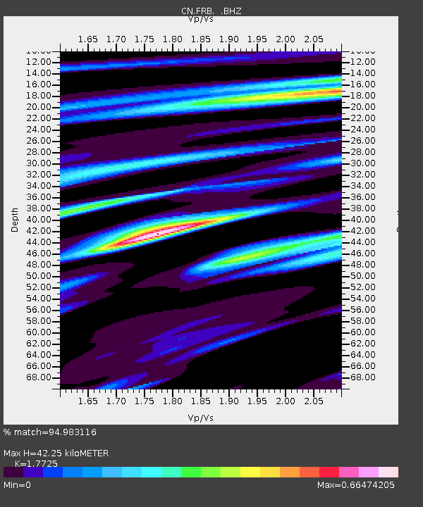
| Estimated Moho Depth: |
42.25 km |
| Estimated Crust Vp/Vs: |
1.77 |
| Assumed Crust Vp: |
6.419 km/s |
| Estimated Crust Vs: |
3.622 km/s |
| Estimated Crust Poisson's Ratio: |
0.27 |
|
| Radial Match: |
94.983116 % |
| Radial Bump: |
317 |
| Transverse Match: |
75.621376 % |
| Transverse Bump: |
400 |
| SOD ConfigId: |
414626 |
| Insert Time: |
2012-01-13 07:21:04.002 +0000 |
| GWidth: |
2.5 |
| Max Bumps: |
400 |
| Tol: |
0.001 |
|

Signal To Noise
| Channel | StoN | STA | LTA |
| CN:FRB: :BHZ:20110824T17:56:44.449988Z | 15.922122 | 1.5933974E-5 | 1.0007443E-6 |
| CN:FRB: :BHN:20110824T17:56:44.449988Z | 16.476343 | 8.0126665E-6 | 4.8631335E-7 |
| CN:FRB: :BHE:20110824T17:56:44.449988Z | 1.6931032 | 1.4446614E-6 | 8.532625E-7 |
| Arrivals |
| Ps | 5.3 SECOND |
| PpPs | 18 SECOND |
| PsPs/PpSs | 23 SECOND |


