You are here: Home > Network List > G - GEOSCOPE Stations List
> Station PPTF Pamatai - Papeete - Tahiti island - French Polynesia, France > Earthquake Result Viewer
PPTF Pamatai - Papeete - Tahiti island - French Polynesia, France - Earthquake Result Viewer
| Earthquake location: |
Peru-Brazil Border Region |
| Earthquake latitude/longitude: |
-7.6/-74.5 |
| Earthquake time(UTC): |
2011/08/24 (236) 17:46:11 GMT |
| Earthquake Depth: |
147 km |
| Earthquake Magnitude: |
6.8 MB, 7.0 MW, 7.0 MW |
| Earthquake Catalog/Contributor: |
WHDF/NEIC |
|
| Network: |
G GEOSCOPE |
| Station: |
PPTF Pamatai - Papeete - Tahiti island - French Polynesia, France |
| Lat/Lon: |
17.59 S/149.57 W |
| Elevation: |
705 m |
|
| Distance: |
73.5 deg |
| Az: |
253.945 deg |
| Baz: |
92.937 deg |
| Ray Param: |
0.052573357 |
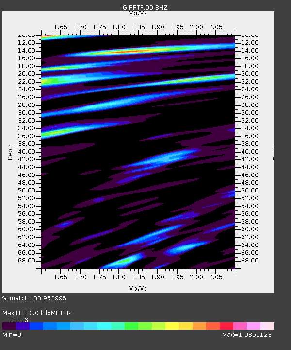
| Estimated Moho Depth: |
10.0 km |
| Estimated Crust Vp/Vs: |
1.60 |
| Assumed Crust Vp: |
4.24 km/s |
| Estimated Crust Vs: |
2.65 km/s |
| Estimated Crust Poisson's Ratio: |
0.18 |
|
| Radial Match: |
83.952995 % |
| Radial Bump: |
400 |
| Transverse Match: |
73.54519 % |
| Transverse Bump: |
400 |
| SOD ConfigId: |
414626 |
| Insert Time: |
2012-01-13 07:21:48.443 +0000 |
| GWidth: |
2.5 |
| Max Bumps: |
400 |
| Tol: |
0.001 |
|

Signal To Noise
| Channel | StoN | STA | LTA |
| G:PPTF:00:BHZ:20110824T17:56:57.350012Z | 6.9783754 | 1.6009151E-5 | 2.2941088E-6 |
| G:PPTF:00:BHN:20110824T17:56:57.350012Z | 0.9009807 | 2.1232197E-6 | 2.3565651E-6 |
| G:PPTF:00:BHE:20110824T17:56:57.350012Z | 2.3714201 | 6.095659E-6 | 2.5704678E-6 |
| Arrivals |
| Ps | 1.4 SECOND |
| PpPs | 6.0 SECOND |
| PsPs/PpSs | 7.5 SECOND |


