You are here: Home > Network List > HW - Hanford Washington Seismic Network Stations List
> Station DDRF Dider Farm, Eltopia, WA, USA > Earthquake Result Viewer
DDRF Dider Farm, Eltopia, WA, USA - Earthquake Result Viewer
| Earthquake location: |
Peru-Brazil Border Region |
| Earthquake latitude/longitude: |
-7.6/-74.5 |
| Earthquake time(UTC): |
2011/08/24 (236) 17:46:11 GMT |
| Earthquake Depth: |
147 km |
| Earthquake Magnitude: |
6.8 MB, 7.0 MW, 7.0 MW |
| Earthquake Catalog/Contributor: |
WHDF/NEIC |
|
| Network: |
HW Hanford Washington Seismic Network |
| Station: |
DDRF Dider Farm, Eltopia, WA, USA |
| Lat/Lon: |
46.49 N/119.06 W |
| Elevation: |
233 m |
|
| Distance: |
66.9 deg |
| Az: |
328.206 deg |
| Baz: |
130.895 deg |
| Ray Param: |
0.056915052 |
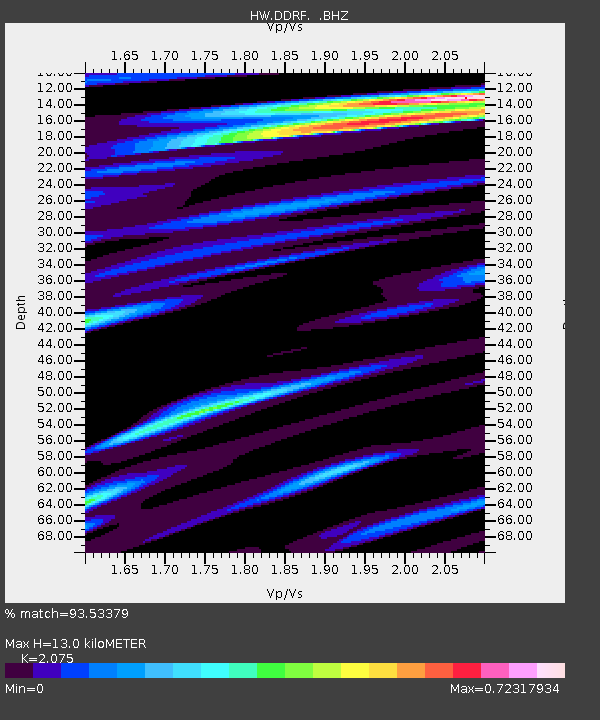
| Estimated Moho Depth: |
13.0 km |
| Estimated Crust Vp/Vs: |
2.08 |
| Assumed Crust Vp: |
6.419 km/s |
| Estimated Crust Vs: |
3.094 km/s |
| Estimated Crust Poisson's Ratio: |
0.35 |
|
| Radial Match: |
93.53379 % |
| Radial Bump: |
400 |
| Transverse Match: |
76.20153 % |
| Transverse Bump: |
400 |
| SOD ConfigId: |
414626 |
| Insert Time: |
2012-01-13 07:23:04.645 +0000 |
| GWidth: |
2.5 |
| Max Bumps: |
400 |
| Tol: |
0.001 |
|

Signal To Noise
| Channel | StoN | STA | LTA |
| HW:DDRF: :BHZ:20110824T17:56:17.100012Z | 75.489235 | 1.0171723E-5 | 1.3474401E-7 |
| HW:DDRF: :BHN:20110824T17:56:17.100012Z | 20.064325 | 2.603585E-6 | 1.297619E-7 |
| HW:DDRF: :BHE:20110824T17:56:17.100012Z | 22.01206 | 3.438101E-6 | 1.5619169E-7 |
| Arrivals |
| Ps | 2.3 SECOND |
| PpPs | 6.0 SECOND |
| PsPs/PpSs | 8.3 SECOND |


