You are here: Home > Network List > IM - International Miscellaneous Stations Stations List
> Station PD31 PDAR Array, Pinedale, WY, USA > Earthquake Result Viewer
PD31 PDAR Array, Pinedale, WY, USA - Earthquake Result Viewer
| Earthquake location: |
Peru-Brazil Border Region |
| Earthquake latitude/longitude: |
-7.6/-74.5 |
| Earthquake time(UTC): |
2011/08/24 (236) 17:46:11 GMT |
| Earthquake Depth: |
147 km |
| Earthquake Magnitude: |
6.8 MB, 7.0 MW, 7.0 MW |
| Earthquake Catalog/Contributor: |
WHDF/NEIC |
|
| Network: |
IM International Miscellaneous Stations |
| Station: |
PD31 PDAR Array, Pinedale, WY, USA |
| Lat/Lon: |
42.77 N/109.56 W |
| Elevation: |
2219 m |
|
| Distance: |
59.4 deg |
| Az: |
330.602 deg |
| Baz: |
138.643 deg |
| Ray Param: |
0.06172915 |
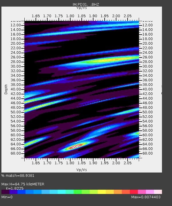
| Estimated Moho Depth: |
64.75 km |
| Estimated Crust Vp/Vs: |
1.82 |
| Assumed Crust Vp: |
6.161 km/s |
| Estimated Crust Vs: |
3.38 km/s |
| Estimated Crust Poisson's Ratio: |
0.28 |
|
| Radial Match: |
88.9381 % |
| Radial Bump: |
400 |
| Transverse Match: |
83.18005 % |
| Transverse Bump: |
400 |
| SOD ConfigId: |
414626 |
| Insert Time: |
2012-01-13 07:23:14.568 +0000 |
| GWidth: |
2.5 |
| Max Bumps: |
400 |
| Tol: |
0.001 |
|

Signal To Noise
| Channel | StoN | STA | LTA |
| IM:PD31: :BHZ:20110824T17:55:28.225012Z | 221.31224 | 4.2986372E-7 | 1.9423405E-9 |
| IM:PD31: :BHN:20110824T17:55:28.225012Z | 60.605812 | 1.4713758E-7 | 2.42778E-9 |
| IM:PD31: :BHE:20110824T17:55:28.225012Z | 60.646225 | 1.7060779E-7 | 2.8131644E-9 |
| Arrivals |
| Ps | 9.0 SECOND |
| PpPs | 28 SECOND |
| PsPs/PpSs | 37 SECOND |


