You are here: Home > Network List > IW - Intermountain West Stations List
> Station REDW Red Top Meadow, Wyoming, USA > Earthquake Result Viewer
REDW Red Top Meadow, Wyoming, USA - Earthquake Result Viewer
| Earthquake location: |
Peru-Brazil Border Region |
| Earthquake latitude/longitude: |
-7.6/-74.5 |
| Earthquake time(UTC): |
2011/08/24 (236) 17:46:11 GMT |
| Earthquake Depth: |
147 km |
| Earthquake Magnitude: |
6.8 MB, 7.0 MW, 7.0 MW |
| Earthquake Catalog/Contributor: |
WHDF/NEIC |
|
| Network: |
IW Intermountain West |
| Station: |
REDW Red Top Meadow, Wyoming, USA |
| Lat/Lon: |
43.36 N/110.85 W |
| Elevation: |
2192 m |
|
| Distance: |
60.5 deg |
| Az: |
330.246 deg |
| Baz: |
137.584 deg |
| Ray Param: |
0.061025243 |
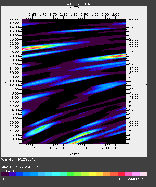
| Estimated Moho Depth: |
24.5 km |
| Estimated Crust Vp/Vs: |
1.60 |
| Assumed Crust Vp: |
6.207 km/s |
| Estimated Crust Vs: |
3.879 km/s |
| Estimated Crust Poisson's Ratio: |
0.18 |
|
| Radial Match: |
93.298645 % |
| Radial Bump: |
400 |
| Transverse Match: |
84.05643 % |
| Transverse Bump: |
400 |
| SOD ConfigId: |
414626 |
| Insert Time: |
2012-01-13 07:23:47.493 +0000 |
| GWidth: |
2.5 |
| Max Bumps: |
400 |
| Tol: |
0.001 |
|

Signal To Noise
| Channel | StoN | STA | LTA |
| IW:REDW: :BHZ:20110824T17:55:35.564978Z | 120.61502 | 1.3882847E-5 | 1.15100484E-7 |
| IW:REDW: :BHN:20110824T17:55:35.564978Z | 46.69532 | 6.547071E-6 | 1.4020829E-7 |
| IW:REDW: :BHE:20110824T17:55:35.564978Z | 33.17821 | 4.556171E-6 | 1.373242E-7 |
| Arrivals |
| Ps | 2.5 SECOND |
| PpPs | 9.8 SECOND |
| PsPs/PpSs | 12 SECOND |


