You are here: Home > Network List > LD - Lamont-Doherty Cooperative Seismographic Network Stations List
> Station ODNJ Ogdensburg, New Jersey > Earthquake Result Viewer
ODNJ Ogdensburg, New Jersey - Earthquake Result Viewer
| Earthquake location: |
Peru-Brazil Border Region |
| Earthquake latitude/longitude: |
-7.6/-74.5 |
| Earthquake time(UTC): |
2011/08/24 (236) 17:46:11 GMT |
| Earthquake Depth: |
147 km |
| Earthquake Magnitude: |
6.8 MB, 7.0 MW, 7.0 MW |
| Earthquake Catalog/Contributor: |
WHDF/NEIC |
|
| Network: |
LD Lamont-Doherty Cooperative Seismographic Network |
| Station: |
ODNJ Ogdensburg, New Jersey |
| Lat/Lon: |
41.08 N/74.61 W |
| Elevation: |
187 m |
|
| Distance: |
48.5 deg |
| Az: |
359.919 deg |
| Baz: |
179.893 deg |
| Ray Param: |
0.06879757 |
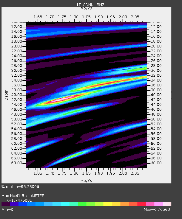
| Estimated Moho Depth: |
41.5 km |
| Estimated Crust Vp/Vs: |
1.75 |
| Assumed Crust Vp: |
6.283 km/s |
| Estimated Crust Vs: |
3.596 km/s |
| Estimated Crust Poisson's Ratio: |
0.26 |
|
| Radial Match: |
96.28006 % |
| Radial Bump: |
385 |
| Transverse Match: |
86.32124 % |
| Transverse Bump: |
400 |
| SOD ConfigId: |
414626 |
| Insert Time: |
2012-01-13 07:25:25.902 +0000 |
| GWidth: |
2.5 |
| Max Bumps: |
400 |
| Tol: |
0.001 |
|

Signal To Noise
| Channel | StoN | STA | LTA |
| LD:ODNJ: :BHZ:20110824T17:54:08.894995Z | 60.06048 | 7.734735E-6 | 1.2878245E-7 |
| LD:ODNJ: :BHN:20110824T17:54:08.894995Z | 37.028313 | 3.9843862E-6 | 1.07603775E-7 |
| LD:ODNJ: :BHE:20110824T17:54:08.894995Z | 4.45381 | 5.395601E-7 | 1.2114575E-7 |
| Arrivals |
| Ps | 5.2 SECOND |
| PpPs | 17 SECOND |
| PsPs/PpSs | 22 SECOND |


