You are here: Home > Network List > MN - MEDNET Project Stations List
> Station WDD Wield Dalam, Malta > Earthquake Result Viewer
WDD Wield Dalam, Malta - Earthquake Result Viewer
| Earthquake location: |
Peru-Brazil Border Region |
| Earthquake latitude/longitude: |
-7.6/-74.5 |
| Earthquake time(UTC): |
2011/08/24 (236) 17:46:11 GMT |
| Earthquake Depth: |
147 km |
| Earthquake Magnitude: |
6.8 MB, 7.0 MW, 7.0 MW |
| Earthquake Catalog/Contributor: |
WHDF/NEIC |
|
| Network: |
MN MEDNET Project |
| Station: |
WDD Wield Dalam, Malta |
| Lat/Lon: |
35.87 N/14.52 E |
| Elevation: |
41 m |
|
| Distance: |
93.7 deg |
| Az: |
54.467 deg |
| Baz: |
263.273 deg |
| Ray Param: |
0.041128363 |
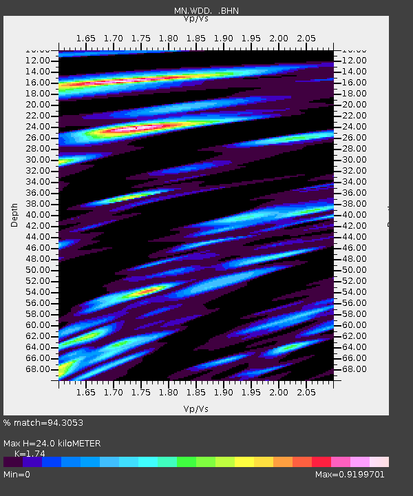
| Estimated Moho Depth: |
24.0 km |
| Estimated Crust Vp/Vs: |
1.74 |
| Assumed Crust Vp: |
4.05 km/s |
| Estimated Crust Vs: |
2.328 km/s |
| Estimated Crust Poisson's Ratio: |
0.25 |
|
| Radial Match: |
94.3053 % |
| Radial Bump: |
400 |
| Transverse Match: |
87.94898 % |
| Transverse Bump: |
400 |
| SOD ConfigId: |
414626 |
| Insert Time: |
2012-01-13 07:26:14.985 +0000 |
| GWidth: |
2.5 |
| Max Bumps: |
400 |
| Tol: |
0.001 |
|

Signal To Noise
| Channel | StoN | STA | LTA |
| MN:WDD: :BHZ:20110824T17:58:40.043005Z | 16.132133 | 2.7661272E-6 | 1.7146691E-7 |
| MN:WDD: :BHN:20110824T17:58:40.043005Z | 1.5210416 | 1.8213903E-7 | 1.1974625E-7 |
| MN:WDD: :BHE:20110824T17:58:40.043005Z | 6.3747454 | 7.6517813E-7 | 1.2003274E-7 |
| Arrivals |
| Ps | 4.4 SECOND |
| PpPs | 16 SECOND |
| PsPs/PpSs | 21 SECOND |


