You are here: Home > Network List > MN - MEDNET Project Stations List
> Station TUE Stuetta, Italy > Earthquake Result Viewer
TUE Stuetta, Italy - Earthquake Result Viewer
| Earthquake location: |
Peru-Brazil Border Region |
| Earthquake latitude/longitude: |
-7.6/-74.5 |
| Earthquake time(UTC): |
2011/08/24 (236) 17:46:11 GMT |
| Earthquake Depth: |
147 km |
| Earthquake Magnitude: |
6.8 MB, 7.0 MW, 7.0 MW |
| Earthquake Catalog/Contributor: |
WHDF/NEIC |
|
| Network: |
MN MEDNET Project |
| Station: |
TUE Stuetta, Italy |
| Lat/Lon: |
46.47 N/9.35 E |
| Elevation: |
1924 m |
|
| Distance: |
91.3 deg |
| Az: |
43.421 deg |
| Baz: |
260.34 deg |
| Ray Param: |
0.041568566 |
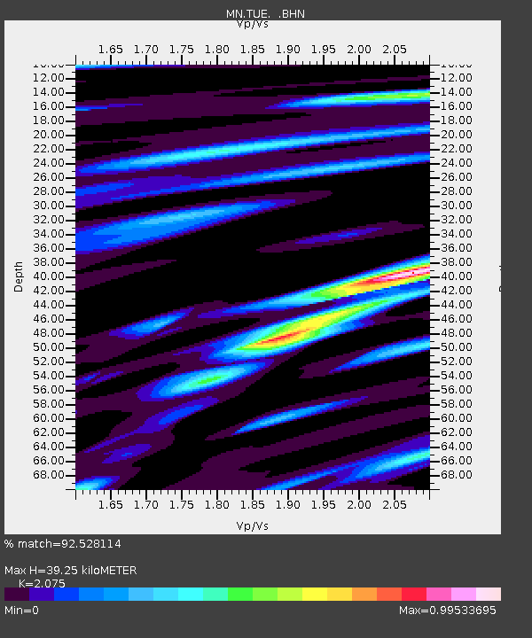
| Estimated Moho Depth: |
39.25 km |
| Estimated Crust Vp/Vs: |
2.08 |
| Assumed Crust Vp: |
6.416 km/s |
| Estimated Crust Vs: |
3.092 km/s |
| Estimated Crust Poisson's Ratio: |
0.35 |
|
| Radial Match: |
92.528114 % |
| Radial Bump: |
400 |
| Transverse Match: |
86.14721 % |
| Transverse Bump: |
400 |
| SOD ConfigId: |
414626 |
| Insert Time: |
2012-01-13 07:26:23.057 +0000 |
| GWidth: |
2.5 |
| Max Bumps: |
400 |
| Tol: |
0.001 |
|
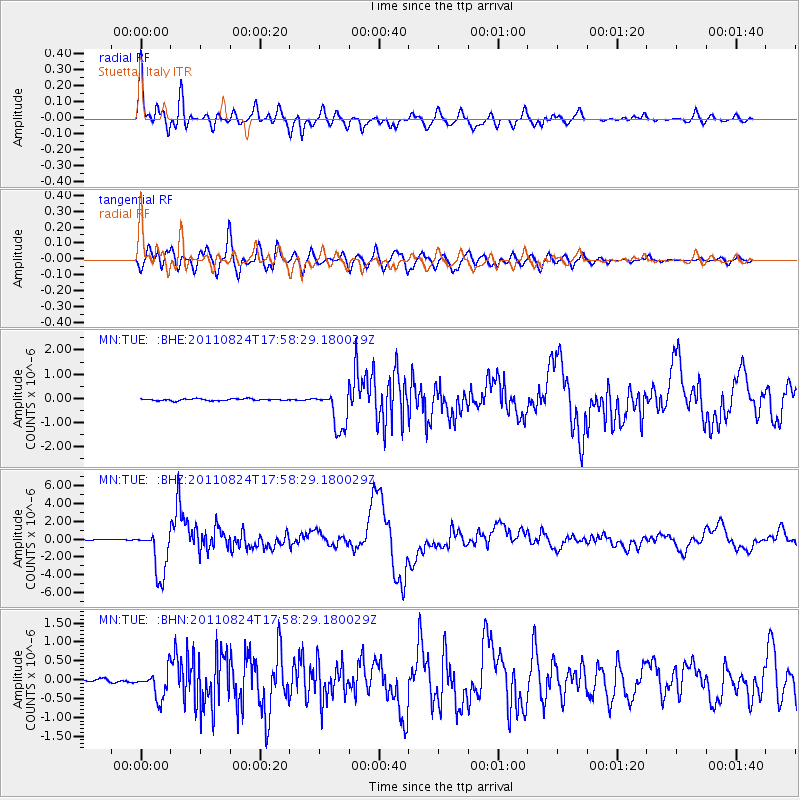
Signal To Noise
| Channel | StoN | STA | LTA |
| MN:TUE: :BHZ:20110824T17:58:29.180029Z | 56.94159 | 2.6543803E-6 | 4.6615842E-8 |
| MN:TUE: :BHN:20110824T17:58:29.180029Z | 6.2940006 | 3.7335076E-7 | 5.9318513E-8 |
| MN:TUE: :BHE:20110824T17:58:29.180029Z | 22.036114 | 8.291048E-7 | 3.762482E-8 |
| Arrivals |
| Ps | 6.7 SECOND |
| PpPs | 18 SECOND |
| PsPs/PpSs | 25 SECOND |


