You are here: Home > Network List > NE - New England Seismic Network Stations List
> Station FFD Franklin Falls Dam, NH > Earthquake Result Viewer
FFD Franklin Falls Dam, NH - Earthquake Result Viewer
| Earthquake location: |
Peru-Brazil Border Region |
| Earthquake latitude/longitude: |
-7.6/-74.5 |
| Earthquake time(UTC): |
2011/08/24 (236) 17:46:11 GMT |
| Earthquake Depth: |
147 km |
| Earthquake Magnitude: |
6.8 MB, 7.0 MW, 7.0 MW |
| Earthquake Catalog/Contributor: |
WHDF/NEIC |
|
| Network: |
NE New England Seismic Network |
| Station: |
FFD Franklin Falls Dam, NH |
| Lat/Lon: |
43.47 N/71.65 W |
| Elevation: |
131 m |
|
| Distance: |
50.9 deg |
| Az: |
2.692 deg |
| Baz: |
183.666 deg |
| Ray Param: |
0.06723457 |
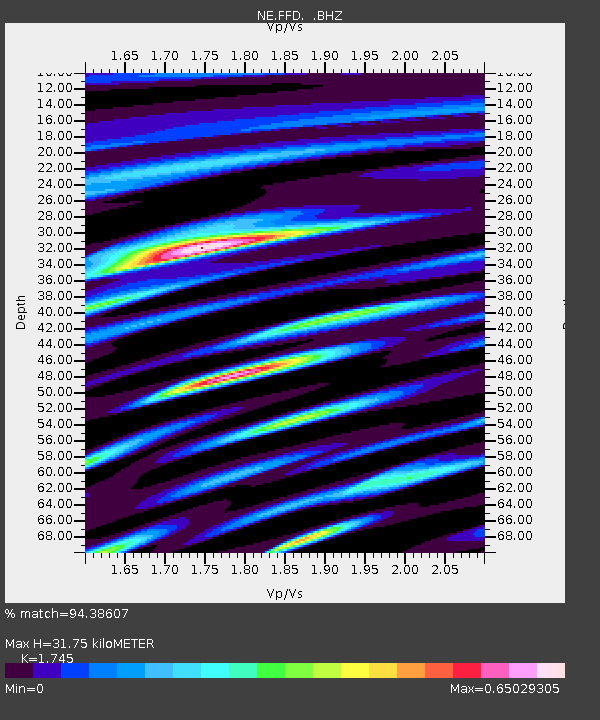
| Estimated Moho Depth: |
31.75 km |
| Estimated Crust Vp/Vs: |
1.75 |
| Assumed Crust Vp: |
6.419 km/s |
| Estimated Crust Vs: |
3.679 km/s |
| Estimated Crust Poisson's Ratio: |
0.26 |
|
| Radial Match: |
94.38607 % |
| Radial Bump: |
400 |
| Transverse Match: |
84.02334 % |
| Transverse Bump: |
400 |
| SOD ConfigId: |
414626 |
| Insert Time: |
2012-01-13 07:27:21.006 +0000 |
| GWidth: |
2.5 |
| Max Bumps: |
400 |
| Tol: |
0.001 |
|

Signal To Noise
| Channel | StoN | STA | LTA |
| NE:FFD: :BHZ:20110824T17:54:27.38999Z | 25.697279 | 6.7176475E-6 | 2.6141475E-7 |
| NE:FFD: :BHN:20110824T17:54:27.38999Z | 11.214948 | 4.336116E-6 | 3.866372E-7 |
| NE:FFD: :BHE:20110824T17:54:27.38999Z | 2.9270604 | 1.0186518E-6 | 3.480119E-7 |
| Arrivals |
| Ps | 3.9 SECOND |
| PpPs | 13 SECOND |
| PsPs/PpSs | 17 SECOND |


