You are here: Home > Network List > TA - USArray Transportable Network (new EarthScope stations) Stations List
> Station 121A Cookes Peak, Deming, NM, USA > Earthquake Result Viewer
121A Cookes Peak, Deming, NM, USA - Earthquake Result Viewer
| Earthquake location: |
Peru-Brazil Border Region |
| Earthquake latitude/longitude: |
-7.6/-74.5 |
| Earthquake time(UTC): |
2011/08/24 (236) 17:46:11 GMT |
| Earthquake Depth: |
147 km |
| Earthquake Magnitude: |
6.8 MB, 7.0 MW, 7.0 MW |
| Earthquake Catalog/Contributor: |
WHDF/NEIC |
|
| Network: |
TA USArray Transportable Network (new EarthScope stations) |
| Station: |
121A Cookes Peak, Deming, NM, USA |
| Lat/Lon: |
32.53 N/107.79 W |
| Elevation: |
1652 m |
|
| Distance: |
51.0 deg |
| Az: |
323.401 deg |
| Baz: |
135.603 deg |
| Ray Param: |
0.06719869 |
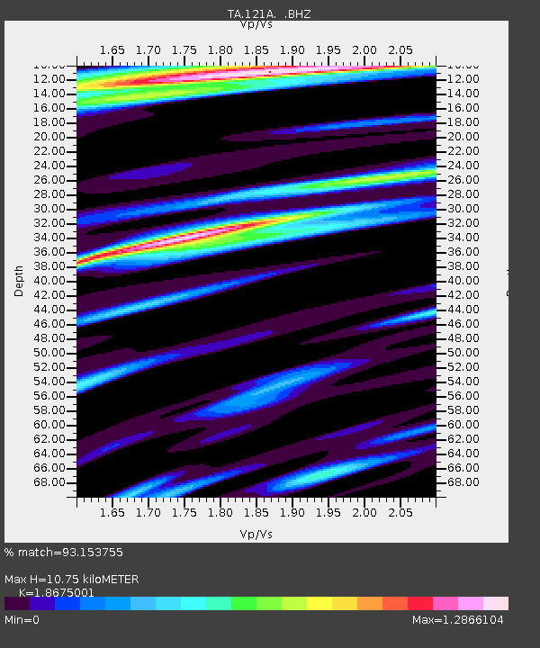
| Estimated Moho Depth: |
10.75 km |
| Estimated Crust Vp/Vs: |
1.87 |
| Assumed Crust Vp: |
6.502 km/s |
| Estimated Crust Vs: |
3.481 km/s |
| Estimated Crust Poisson's Ratio: |
0.30 |
|
| Radial Match: |
93.153755 % |
| Radial Bump: |
400 |
| Transverse Match: |
84.909195 % |
| Transverse Bump: |
400 |
| SOD ConfigId: |
414626 |
| Insert Time: |
2012-01-13 07:29:29.742 +0000 |
| GWidth: |
2.5 |
| Max Bumps: |
400 |
| Tol: |
0.001 |
|
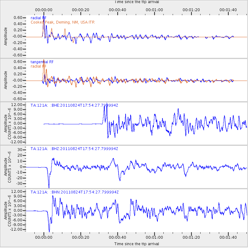
Signal To Noise
| Channel | StoN | STA | LTA |
| TA:121A: :BHZ:20110824T17:54:27.799994Z | 114.966774 | 1.2595018E-5 | 1.0955355E-7 |
| TA:121A: :BHN:20110824T17:54:27.799994Z | 70.74411 | 5.203529E-6 | 7.3554226E-8 |
| TA:121A: :BHE:20110824T17:54:27.799994Z | 69.59538 | 5.127335E-6 | 7.36735E-8 |
| Arrivals |
| Ps | 1.5 SECOND |
| PpPs | 4.5 SECOND |
| PsPs/PpSs | 6.0 SECOND |


