You are here: Home > Network List > TA - USArray Transportable Network (new EarthScope stations) Stations List
> Station S22A 4UR Ranch, Creede, CO, USA > Earthquake Result Viewer
S22A 4UR Ranch, Creede, CO, USA - Earthquake Result Viewer
| Earthquake location: |
Peru-Brazil Border Region |
| Earthquake latitude/longitude: |
-7.6/-74.5 |
| Earthquake time(UTC): |
2011/08/24 (236) 17:46:11 GMT |
| Earthquake Depth: |
147 km |
| Earthquake Magnitude: |
6.8 MB, 7.0 MW, 7.0 MW |
| Earthquake Catalog/Contributor: |
WHDF/NEIC |
|
| Network: |
TA USArray Transportable Network (new EarthScope stations) |
| Station: |
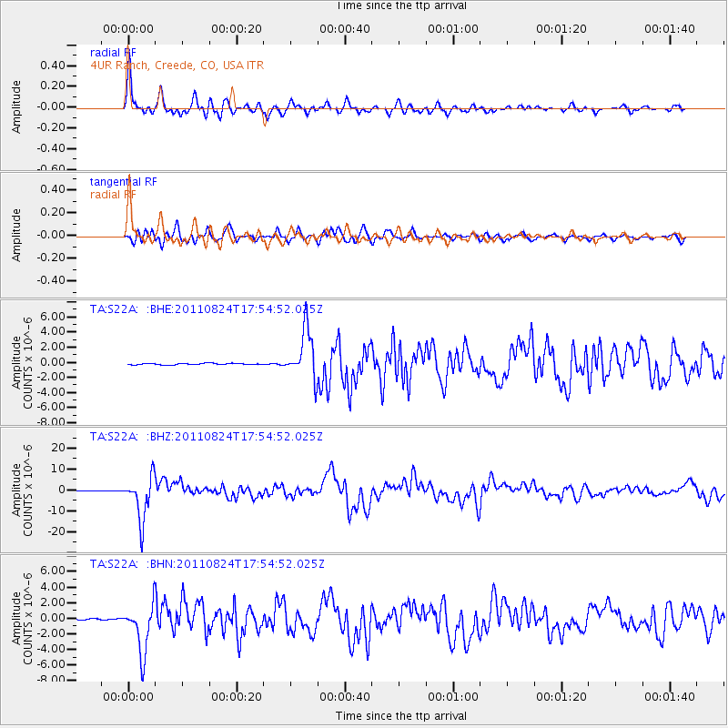
S22A 4UR Ranch, Creede, CO, USA |
| Lat/Lon: |
37.75 N/106.83 W |
| Elevation: |
2626 m |
|
| Distance: |
54.3 deg |
| Az: |
328.553 deg |
| Baz: |
139.28 deg |
| Ray Param: |
0.0650601 |
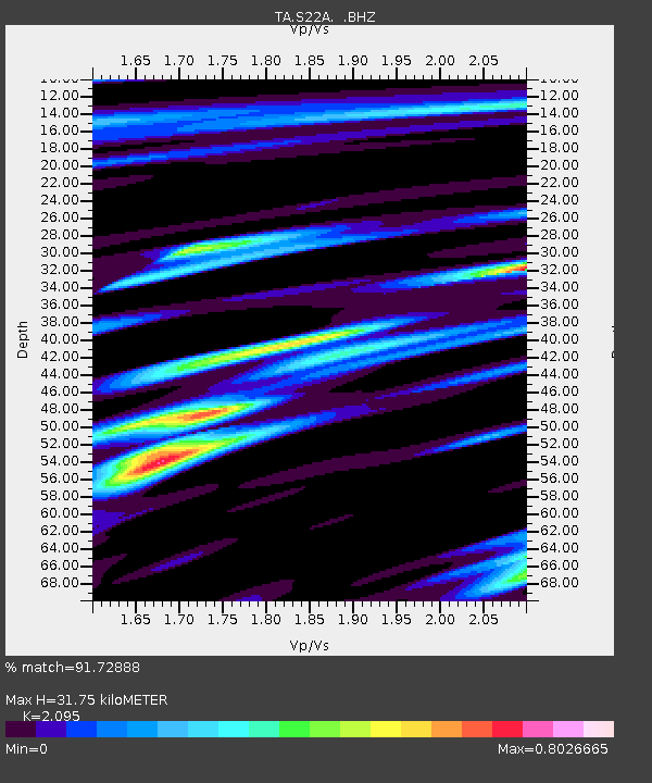
| Estimated Moho Depth: |
31.75 km |
| Estimated Crust Vp/Vs: |
2.10 |
| Assumed Crust Vp: |
6.159 km/s |
| Estimated Crust Vs: |
2.94 km/s |
| Estimated Crust Poisson's Ratio: |
0.35 |
|
| Radial Match: |
91.72888 % |
| Radial Bump: |
400 |
| Transverse Match: |
85.36006 % |
| Transverse Bump: |
400 |
| SOD ConfigId: |
414626 |
| Insert Time: |
2012-01-13 07:29:57.277 +0000 |
| GWidth: |
2.5 |
| Max Bumps: |
400 |
| Tol: |
0.001 |
|
Signal To Noise
| Channel | StoN | STA | LTA |
| TA:S22A: :BHZ:20110824T17:54:52.025Z | 68.88443 | 1.0529323E-5 | 1.5285491E-7 |
| TA:S22A: :BHN:20110824T17:54:52.025Z | 26.937944 | 3.1652655E-6 | 1.1750211E-7 |
| TA:S22A: :BHE:20110824T17:54:52.025Z | 33.51265 | 3.3172405E-6 | 9.898473E-8 |
| Arrivals |
| Ps | 5.9 SECOND |
| PpPs | 15 SECOND |
| PsPs/PpSs | 21 SECOND |


