You are here: Home > Network List > TA - USArray Transportable Network (new EarthScope stations) Stations List
> Station U32A Winter Ranch, Mooreland, OK, USA > Earthquake Result Viewer
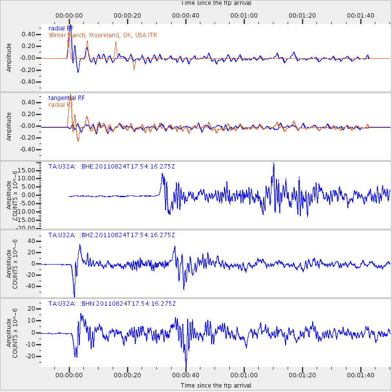
U32A Winter Ranch, Mooreland, OK, USA - Earthquake Result Viewer
| Earthquake location: |
Peru-Brazil Border Region |
| Earthquake latitude/longitude: |
-7.6/-74.5 |
| Earthquake time(UTC): |
2011/08/24 (236) 17:46:11 GMT |
| Earthquake Depth: |
147 km |
| Earthquake Magnitude: |
6.8 MB, 7.0 MW, 7.0 MW |
| Earthquake Catalog/Contributor: |
WHDF/NEIC |
|
| Network: |
TA USArray Transportable Network (new EarthScope stations) |
| Station: |
U32A Winter Ranch, Mooreland, OK, USA |
| Lat/Lon: |
36.38 N/99.00 W |
| Elevation: |
525 m |
|
| Distance: |
49.5 deg |
| Az: |
333.896 deg |
| Baz: |
147.286 deg |
| Ray Param: |
0.06818479 |
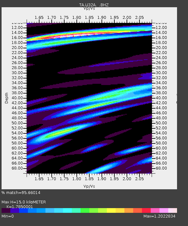
| Estimated Moho Depth: |
15.0 km |
| Estimated Crust Vp/Vs: |
1.79 |
| Assumed Crust Vp: |
6.426 km/s |
| Estimated Crust Vs: |
3.6 km/s |
| Estimated Crust Poisson's Ratio: |
0.27 |
|
| Radial Match: |
95.66014 % |
| Radial Bump: |
400 |
| Transverse Match: |
87.35098 % |
| Transverse Bump: |
400 |
| SOD ConfigId: |
414626 |
| Insert Time: |
2012-01-13 07:31:58.890 +0000 |
| GWidth: |
2.5 |
| Max Bumps: |
400 |
| Tol: |
0.001 |
|
Signal To Noise
| Channel | StoN | STA | LTA |
| TA:U32A: :BHZ:20110824T17:54:16.275Z | 123.15011 | 2.0635345E-5 | 1.6756255E-7 |
| TA:U32A: :BHN:20110824T17:54:16.275Z | 58.954277 | 9.94862E-6 | 1.6875144E-7 |
| TA:U32A: :BHE:20110824T17:54:16.275Z | 38.915634 | 6.858259E-6 | 1.7623402E-7 |
| Arrivals |
| Ps | 1.9 SECOND |
| PpPs | 6.1 SECOND |
| PsPs/PpSs | 8.1 SECOND |


