You are here: Home > Network List > TA - USArray Transportable Network (new EarthScope stations) Stations List
> Station 135A Vickery Place, Crowley, TX, USA > Earthquake Result Viewer
135A Vickery Place, Crowley, TX, USA - Earthquake Result Viewer
| Earthquake location: |
Peru-Brazil Border Region |
| Earthquake latitude/longitude: |
-7.6/-74.5 |
| Earthquake time(UTC): |
2011/08/24 (236) 17:46:11 GMT |
| Earthquake Depth: |
147 km |
| Earthquake Magnitude: |
6.8 MB, 7.0 MW, 7.0 MW |
| Earthquake Catalog/Contributor: |
WHDF/NEIC |
|
| Network: |
TA USArray Transportable Network (new EarthScope stations) |
| Station: |
135A Vickery Place, Crowley, TX, USA |
| Lat/Lon: |
32.56 N/97.41 W |
| Elevation: |
270 m |
|
| Distance: |
45.5 deg |
| Az: |
332.603 deg |
| Baz: |
147.309 deg |
| Ray Param: |
0.07068578 |
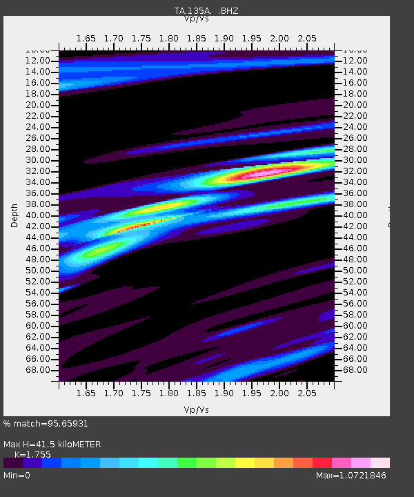
| Estimated Moho Depth: |
41.5 km |
| Estimated Crust Vp/Vs: |
1.75 |
| Assumed Crust Vp: |
6.38 km/s |
| Estimated Crust Vs: |
3.636 km/s |
| Estimated Crust Poisson's Ratio: |
0.26 |
|
| Radial Match: |
95.65931 % |
| Radial Bump: |
351 |
| Transverse Match: |
84.63912 % |
| Transverse Bump: |
400 |
| SOD ConfigId: |
414626 |
| Insert Time: |
2012-01-13 07:34:24.325 +0000 |
| GWidth: |
2.5 |
| Max Bumps: |
400 |
| Tol: |
0.001 |
|

Signal To Noise
| Channel | StoN | STA | LTA |
| TA:135A: :BHZ:20110824T17:53:46.100012Z | 168.20576 | 2.2089514E-5 | 1.3132437E-7 |
| TA:135A: :BHN:20110824T17:53:46.100012Z | 123.98534 | 1.1271887E-5 | 9.091307E-8 |
| TA:135A: :BHE:20110824T17:53:46.100012Z | 49.617195 | 6.8156896E-6 | 1.3736548E-7 |
| Arrivals |
| Ps | 5.2 SECOND |
| PpPs | 17 SECOND |
| PsPs/PpSs | 22 SECOND |


