You are here: Home > Network List > TA - USArray Transportable Network (new EarthScope stations) Stations List
> Station 335A Moody, TX, USA > Earthquake Result Viewer
335A Moody, TX, USA - Earthquake Result Viewer
| Earthquake location: |
Peru-Brazil Border Region |
| Earthquake latitude/longitude: |
-7.6/-74.5 |
| Earthquake time(UTC): |
2011/08/24 (236) 17:46:11 GMT |
| Earthquake Depth: |
147 km |
| Earthquake Magnitude: |
6.8 MB, 7.0 MW, 7.0 MW |
| Earthquake Catalog/Contributor: |
WHDF/NEIC |
|
| Network: |
TA USArray Transportable Network (new EarthScope stations) |
| Station: |
335A Moody, TX, USA |
| Lat/Lon: |
31.28 N/97.43 W |
| Elevation: |
217 m |
|
| Distance: |
44.5 deg |
| Az: |
331.606 deg |
| Baz: |
146.594 deg |
| Ray Param: |
0.071352944 |
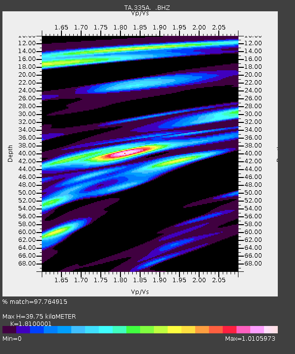
| Estimated Moho Depth: |
39.75 km |
| Estimated Crust Vp/Vs: |
1.81 |
| Assumed Crust Vp: |
6.347 km/s |
| Estimated Crust Vs: |
3.507 km/s |
| Estimated Crust Poisson's Ratio: |
0.28 |
|
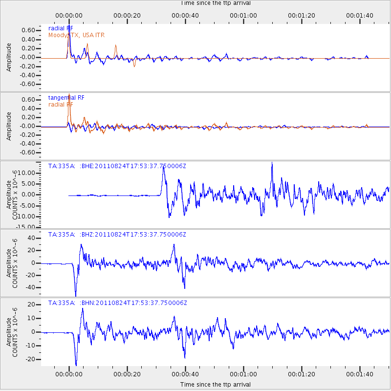
| Radial Match: |
97.764915 % |
| Radial Bump: |
333 |
| Transverse Match: |
88.4366 % |
| Transverse Bump: |
400 |
| SOD ConfigId: |
414626 |
| Insert Time: |
2012-01-13 07:34:49.385 +0000 |
| GWidth: |
2.5 |
| Max Bumps: |
400 |
| Tol: |
0.001 |
|
Signal To Noise
| Channel | StoN | STA | LTA |
| TA:335A: :BHZ:20110824T17:53:37.750006Z | 158.83395 | 2.0626443E-5 | 1.2986166E-7 |
| TA:335A: :BHN:20110824T17:53:37.750006Z | 119.38354 | 9.843138E-6 | 8.2449716E-8 |
| TA:335A: :BHE:20110824T17:53:37.750006Z | 51.72362 | 5.8591177E-6 | 1.1327741E-7 |
| Arrivals |
| Ps | 5.4 SECOND |
| PpPs | 17 SECOND |
| PsPs/PpSs | 22 SECOND |


