You are here: Home > Network List > TA - USArray Transportable Network (new EarthScope stations) Stations List
> Station 138A Matatall Enterprise, Big Sandy, TX, USA > Earthquake Result Viewer
138A Matatall Enterprise, Big Sandy, TX, USA - Earthquake Result Viewer
| Earthquake location: |
Peru-Brazil Border Region |
| Earthquake latitude/longitude: |
-7.6/-74.5 |
| Earthquake time(UTC): |
2011/08/24 (236) 17:46:11 GMT |
| Earthquake Depth: |
147 km |
| Earthquake Magnitude: |
6.8 MB, 7.0 MW, 7.0 MW |
| Earthquake Catalog/Contributor: |
WHDF/NEIC |
|
| Network: |
TA USArray Transportable Network (new EarthScope stations) |
| Station: |
138A Matatall Enterprise, Big Sandy, TX, USA |
| Lat/Lon: |
32.66 N/95.09 W |
| Elevation: |
143 m |
|
| Distance: |
44.6 deg |
| Az: |
335.045 deg |
| Baz: |
150.279 deg |
| Ray Param: |
0.071267694 |
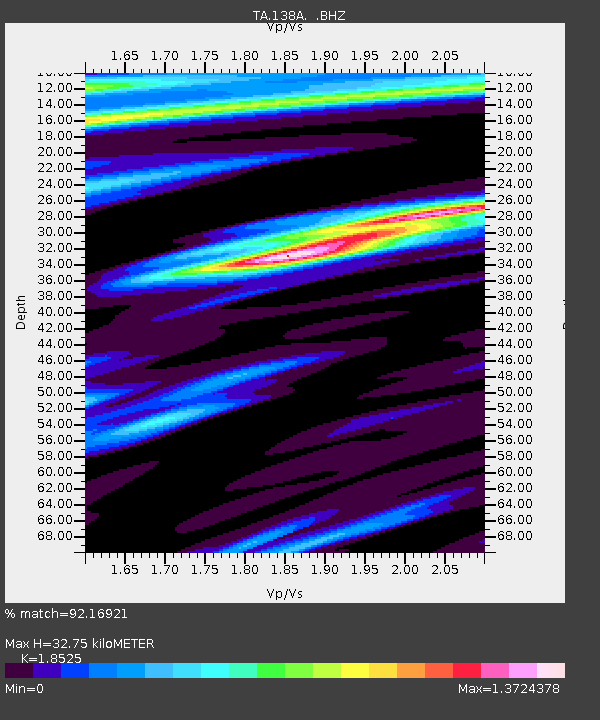
| Estimated Moho Depth: |
32.75 km |
| Estimated Crust Vp/Vs: |
1.85 |
| Assumed Crust Vp: |
6.245 km/s |
| Estimated Crust Vs: |
3.371 km/s |
| Estimated Crust Poisson's Ratio: |
0.29 |
|
| Radial Match: |
92.16921 % |
| Radial Bump: |
366 |
| Transverse Match: |
86.01111 % |
| Transverse Bump: |
400 |
| SOD ConfigId: |
414626 |
| Insert Time: |
2012-01-13 07:37:36.224 +0000 |
| GWidth: |
2.5 |
| Max Bumps: |
400 |
| Tol: |
0.001 |
|

Signal To Noise
| Channel | StoN | STA | LTA |
| TA:138A: :BHZ:20110824T17:53:38.799994Z | 118.60173 | 2.3947645E-5 | 2.0191648E-7 |
| TA:138A: :BHN:20110824T17:53:38.799994Z | 22.454054 | 8.392175E-6 | 3.7374878E-7 |
| TA:138A: :BHE:20110824T17:53:38.799994Z | 8.924665 | 4.1704366E-6 | 4.6729335E-7 |
| Arrivals |
| Ps | 4.7 SECOND |
| PpPs | 14 SECOND |
| PsPs/PpSs | 19 SECOND |


