You are here: Home > Network List > TA - USArray Transportable Network (new EarthScope stations) Stations List
> Station W36A Wetumka, OK, USA > Earthquake Result Viewer
W36A Wetumka, OK, USA - Earthquake Result Viewer
| Earthquake location: |
Peru-Brazil Border Region |
| Earthquake latitude/longitude: |
-7.6/-74.5 |
| Earthquake time(UTC): |
2011/08/24 (236) 17:46:11 GMT |
| Earthquake Depth: |
147 km |
| Earthquake Magnitude: |
6.8 MB, 7.0 MW, 7.0 MW |
| Earthquake Catalog/Contributor: |
WHDF/NEIC |
|
| Network: |
TA USArray Transportable Network (new EarthScope stations) |
| Station: |
W36A Wetumka, OK, USA |
| Lat/Lon: |
35.14 N/96.23 W |
| Elevation: |
251 m |
|
| Distance: |
47.2 deg |
| Az: |
335.615 deg |
| Baz: |
150.044 deg |
| Ray Param: |
0.06961072 |
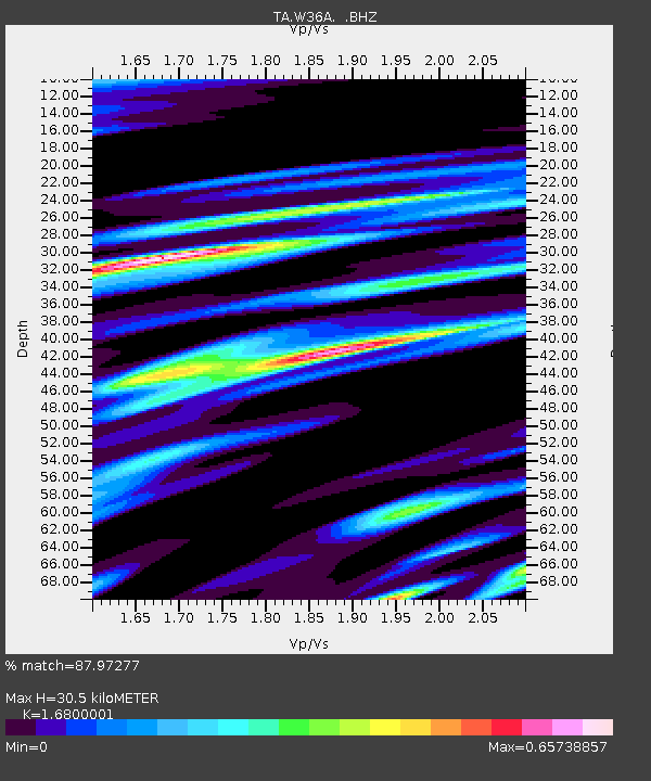
| Estimated Moho Depth: |
30.5 km |
| Estimated Crust Vp/Vs: |
1.68 |
| Assumed Crust Vp: |
6.426 km/s |
| Estimated Crust Vs: |
3.825 km/s |
| Estimated Crust Poisson's Ratio: |
0.23 |
|
| Radial Match: |
87.97277 % |
| Radial Bump: |
400 |
| Transverse Match: |
82.227875 % |
| Transverse Bump: |
400 |
| SOD ConfigId: |
414626 |
| Insert Time: |
2012-01-13 07:38:14.481 +0000 |
| GWidth: |
2.5 |
| Max Bumps: |
400 |
| Tol: |
0.001 |
|
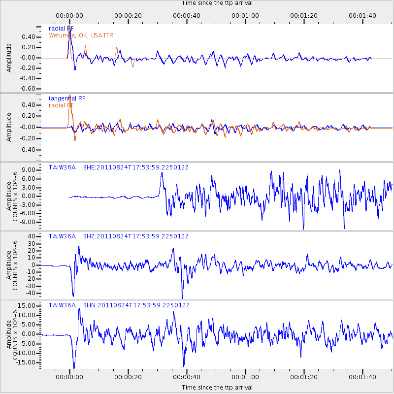
Signal To Noise
| Channel | StoN | STA | LTA |
| TA:W36A: :BHZ:20110824T17:53:59.225012Z | 179.3475 | 1.7118715E-5 | 9.544998E-8 |
| TA:W36A: :BHN:20110824T17:53:59.225012Z | 57.34023 | 8.377898E-6 | 1.4610855E-7 |
| TA:W36A: :BHE:20110824T17:53:59.225012Z | 20.661907 | 4.1910985E-6 | 2.0284179E-7 |
| Arrivals |
| Ps | 3.4 SECOND |
| PpPs | 12 SECOND |
| PsPs/PpSs | 15 SECOND |


