You are here: Home > Network List > TA - USArray Transportable Network (new EarthScope stations) Stations List
> Station W38A Poteau, OK, USA > Earthquake Result Viewer
W38A Poteau, OK, USA - Earthquake Result Viewer
| Earthquake location: |
Peru-Brazil Border Region |
| Earthquake latitude/longitude: |
-7.6/-74.5 |
| Earthquake time(UTC): |
2011/08/24 (236) 17:46:11 GMT |
| Earthquake Depth: |
147 km |
| Earthquake Magnitude: |
6.8 MB, 7.0 MW, 7.0 MW |
| Earthquake Catalog/Contributor: |
WHDF/NEIC |
|
| Network: |
TA USArray Transportable Network (new EarthScope stations) |
| Station: |
W38A Poteau, OK, USA |
| Lat/Lon: |
35.07 N/94.52 W |
| Elevation: |
169 m |
|
| Distance: |
46.5 deg |
| Az: |
337.25 deg |
| Baz: |
152.139 deg |
| Ray Param: |
0.07007406 |
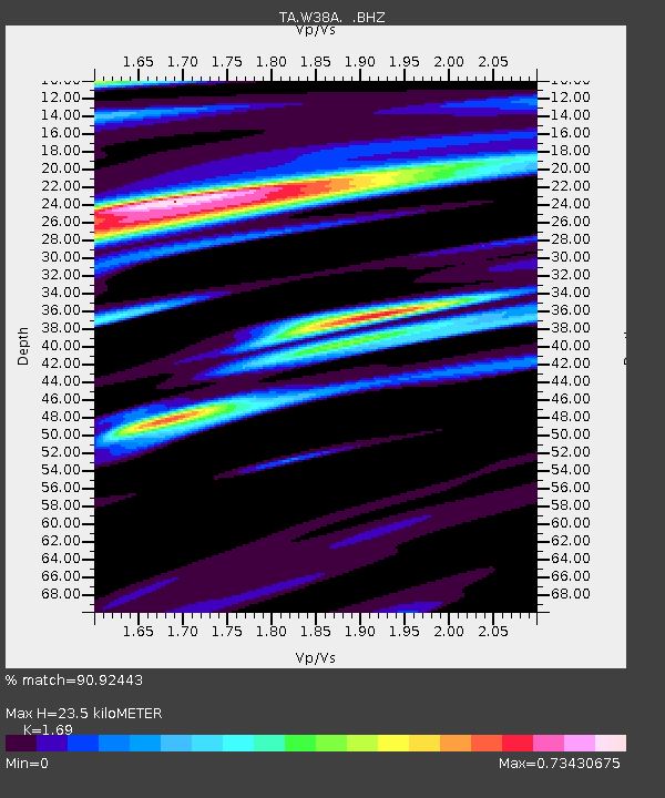
| Estimated Moho Depth: |
23.5 km |
| Estimated Crust Vp/Vs: |
1.69 |
| Assumed Crust Vp: |
6.498 km/s |
| Estimated Crust Vs: |
3.845 km/s |
| Estimated Crust Poisson's Ratio: |
0.23 |
|
| Radial Match: |
90.92443 % |
| Radial Bump: |
400 |
| Transverse Match: |
77.99144 % |
| Transverse Bump: |
400 |
| SOD ConfigId: |
414626 |
| Insert Time: |
2012-01-13 07:38:42.672 +0000 |
| GWidth: |
2.5 |
| Max Bumps: |
400 |
| Tol: |
0.001 |
|

Signal To Noise
| Channel | StoN | STA | LTA |
| TA:W38A: :BHZ:20110824T17:53:53.525Z | 59.931 | 1.7256923E-5 | 2.8794653E-7 |
| TA:W38A: :BHN:20110824T17:53:53.525Z | 28.656149 | 5.115507E-6 | 1.785134E-7 |
| TA:W38A: :BHE:20110824T17:53:53.525Z | 19.197676 | 2.9551081E-6 | 1.5393053E-7 |
| Arrivals |
| Ps | 2.7 SECOND |
| PpPs | 9.1 SECOND |
| PsPs/PpSs | 12 SECOND |


