You are here: Home > Network List > TA - USArray Transportable Network (new EarthScope stations) Stations List
> Station Y38A Idabel, OK, USA > Earthquake Result Viewer
Y38A Idabel, OK, USA - Earthquake Result Viewer
| Earthquake location: |
Peru-Brazil Border Region |
| Earthquake latitude/longitude: |
-7.6/-74.5 |
| Earthquake time(UTC): |
2011/08/24 (236) 17:46:11 GMT |
| Earthquake Depth: |
147 km |
| Earthquake Magnitude: |
6.8 MB, 7.0 MW, 7.0 MW |
| Earthquake Catalog/Contributor: |
WHDF/NEIC |
|
| Network: |
TA USArray Transportable Network (new EarthScope stations) |
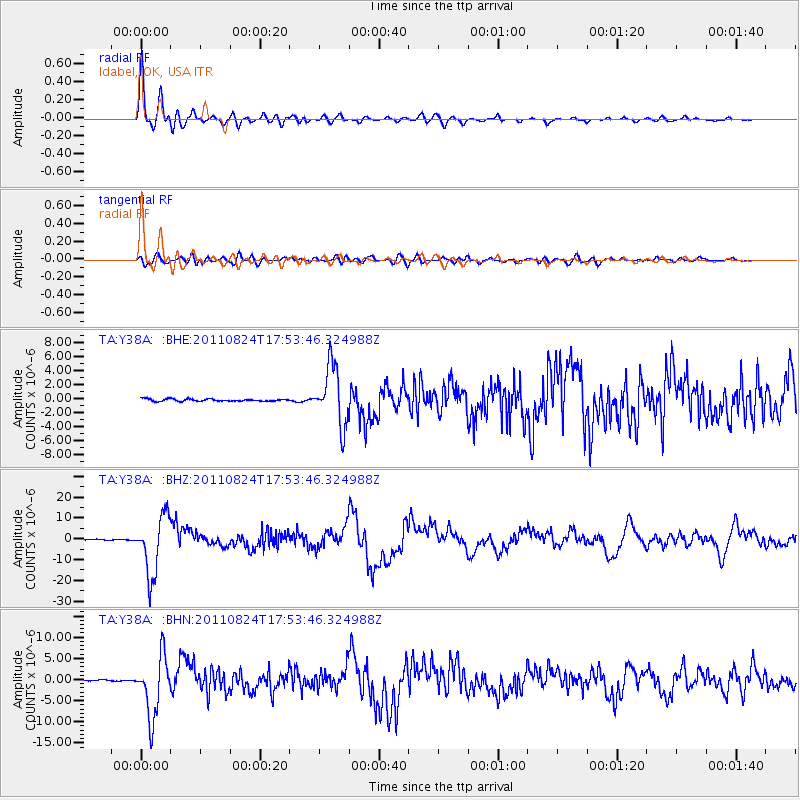
| Station: |
Y38A Idabel, OK, USA |
| Lat/Lon: |
33.93 N/94.73 W |
| Elevation: |
118 m |
|
| Distance: |
45.6 deg |
| Az: |
336.285 deg |
| Baz: |
151.349 deg |
| Ray Param: |
0.070667244 |
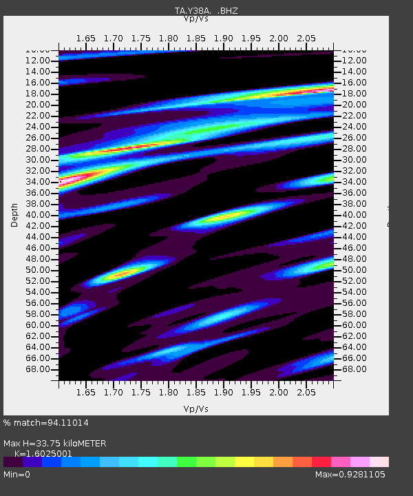
| Estimated Moho Depth: |
33.75 km |
| Estimated Crust Vp/Vs: |
1.60 |
| Assumed Crust Vp: |
6.245 km/s |
| Estimated Crust Vs: |
3.897 km/s |
| Estimated Crust Poisson's Ratio: |
0.18 |
|
| Radial Match: |
94.11014 % |
| Radial Bump: |
400 |
| Transverse Match: |
69.30133 % |
| Transverse Bump: |
400 |
| SOD ConfigId: |
414626 |
| Insert Time: |
2012-01-13 07:39:34.739 +0000 |
| GWidth: |
2.5 |
| Max Bumps: |
400 |
| Tol: |
0.001 |
|
Signal To Noise
| Channel | StoN | STA | LTA |
| TA:Y38A: :BHZ:20110824T17:53:46.324988Z | 98.82405 | 1.4168823E-5 | 1.4337425E-7 |
| TA:Y38A: :BHN:20110824T17:53:46.324988Z | 41.545555 | 7.1329123E-6 | 1.7168894E-7 |
| TA:Y38A: :BHE:20110824T17:53:46.324988Z | 26.153627 | 4.2202246E-6 | 1.6136286E-7 |
| Arrivals |
| Ps | 3.5 SECOND |
| PpPs | 13 SECOND |
| PsPs/PpSs | 17 SECOND |


