You are here: Home > Network List > TA - USArray Transportable Network (new EarthScope stations) Stations List
> Station Y39A Lockesburg, AR, USA > Earthquake Result Viewer
Y39A Lockesburg, AR, USA - Earthquake Result Viewer
| Earthquake location: |
Peru-Brazil Border Region |
| Earthquake latitude/longitude: |
-7.6/-74.5 |
| Earthquake time(UTC): |
2011/08/24 (236) 17:46:11 GMT |
| Earthquake Depth: |
147 km |
| Earthquake Magnitude: |
6.8 MB, 7.0 MW, 7.0 MW |
| Earthquake Catalog/Contributor: |
WHDF/NEIC |
|
| Network: |
TA USArray Transportable Network (new EarthScope stations) |
| Station: |
Y39A Lockesburg, AR, USA |
| Lat/Lon: |
33.94 N/94.09 W |
| Elevation: |
108 m |
|
| Distance: |
45.3 deg |
| Az: |
336.947 deg |
| Baz: |
152.168 deg |
| Ray Param: |
0.070815526 |
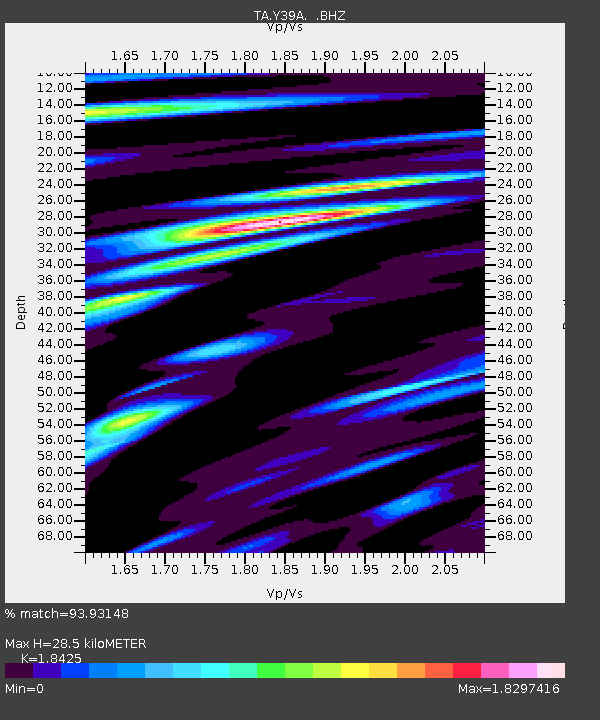
| Estimated Moho Depth: |
28.5 km |
| Estimated Crust Vp/Vs: |
1.84 |
| Assumed Crust Vp: |
6.245 km/s |
| Estimated Crust Vs: |
3.39 km/s |
| Estimated Crust Poisson's Ratio: |
0.29 |
|
| Radial Match: |
93.93148 % |
| Radial Bump: |
400 |
| Transverse Match: |
81.228325 % |
| Transverse Bump: |
400 |
| SOD ConfigId: |
414626 |
| Insert Time: |
2012-01-13 07:39:43.498 +0000 |
| GWidth: |
2.5 |
| Max Bumps: |
400 |
| Tol: |
0.001 |
|

Signal To Noise
| Channel | StoN | STA | LTA |
| TA:Y39A: :BHZ:20110824T17:53:44.424994Z | 114.55809 | 1.5662266E-5 | 1.3671898E-7 |
| TA:Y39A: :BHN:20110824T17:53:44.424994Z | 30.340155 | 8.770734E-6 | 2.8908008E-7 |
| TA:Y39A: :BHE:20110824T17:53:44.424994Z | 17.922678 | 5.0706976E-6 | 2.8292078E-7 |
| Arrivals |
| Ps | 4.1 SECOND |
| PpPs | 12 SECOND |
| PsPs/PpSs | 16 SECOND |


