You are here: Home > Network List > TA - USArray Transportable Network (new EarthScope stations) Stations List
> Station O36A Bolckow, MO, USA > Earthquake Result Viewer
O36A Bolckow, MO, USA - Earthquake Result Viewer

| Earthquake location: |
Peru-Brazil Border Region |
| Earthquake latitude/longitude: |
-7.6/-74.5 |
| Earthquake time(UTC): |
2011/08/24 (236) 17:46:11 GMT |
| Earthquake Depth: |
147 km |
| Earthquake Magnitude: |
6.8 MB, 7.0 MW, 7.0 MW |
| Earthquake Catalog/Contributor: |
WHDF/NEIC |
|
| Network: |
TA USArray Transportable Network (new EarthScope stations) |
| Station: |
O36A Bolckow, MO, USA |
| Lat/Lon: |
40.13 N/94.96 W |
| Elevation: |
306 m |
|
| Distance: |
51.1 deg |
| Az: |
339.891 deg |
| Baz: |
153.609 deg |
| Ray Param: |
0.067095324 |
| Estimated Moho Depth: |
41.0 km |
| Estimated Crust Vp/Vs: |
1.74 |
| Assumed Crust Vp: |
6.498 km/s |
| Estimated Crust Vs: |
3.74 km/s |
| Estimated Crust Poisson's Ratio: |
0.25 |
|
| Radial Match: |
89.443214 % |
| Radial Bump: |
400 |
| Transverse Match: |
58.98301 % |
| Transverse Bump: |
400 |
| SOD ConfigId: |
414626 |
| Insert Time: |
2012-01-13 07:40:41.102 +0000 |
| GWidth: |
2.5 |
| Max Bumps: |
400 |
| Tol: |
0.001 |
|
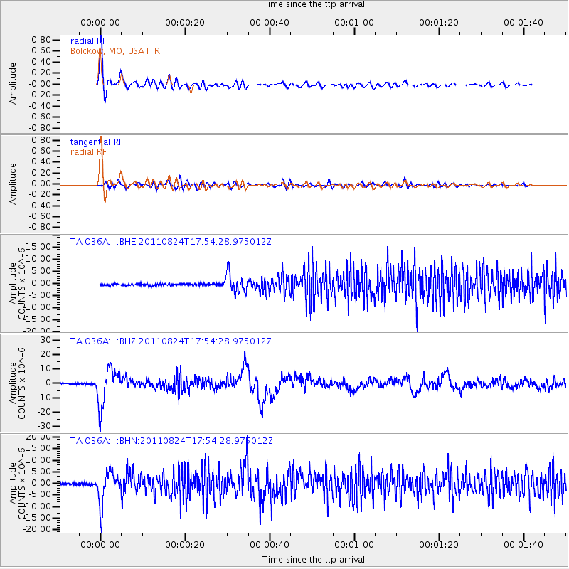
Signal To Noise
| Channel | StoN | STA | LTA |
| TA:O36A: :BHZ:20110824T17:54:28.975012Z | 41.01905 | 1.2903502E-5 | 3.145734E-7 |
| TA:O36A: :BHN:20110824T17:54:28.975012Z | 27.481913 | 7.104225E-6 | 2.5850548E-7 |
| TA:O36A: :BHE:20110824T17:54:28.975012Z | 12.103174 | 3.7871112E-6 | 3.1290233E-7 |
| Arrivals |
| Ps | 4.9 SECOND |
| PpPs | 16 SECOND |
| PsPs/PpSs | 21 SECOND |


