You are here: Home > Network List > TA - USArray Transportable Network (new EarthScope stations) Stations List
> Station P36A Good Intent, Atchison, KS, USA > Earthquake Result Viewer
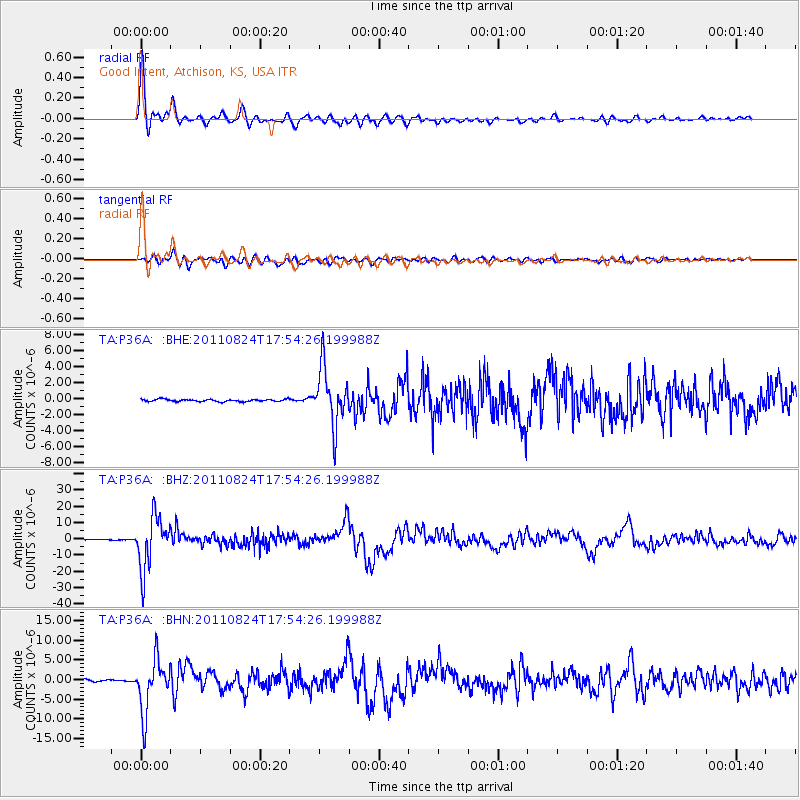
P36A Good Intent, Atchison, KS, USA - Earthquake Result Viewer

| Earthquake location: |
Peru-Brazil Border Region |
| Earthquake latitude/longitude: |
-7.6/-74.5 |
| Earthquake time(UTC): |
2011/08/24 (236) 17:46:11 GMT |
| Earthquake Depth: |
147 km |
| Earthquake Magnitude: |
6.8 MB, 7.0 MW, 7.0 MW |
| Earthquake Catalog/Contributor: |
WHDF/NEIC |
|
| Network: |
TA USArray Transportable Network (new EarthScope stations) |
| Station: |
P36A Good Intent, Atchison, KS, USA |
| Lat/Lon: |
39.62 N/95.21 W |
| Elevation: |
313 m |
|
| Distance: |
50.8 deg |
| Az: |
339.382 deg |
| Baz: |
153.134 deg |
| Ray Param: |
0.067340724 |
| Estimated Moho Depth: |
29.25 km |
| Estimated Crust Vp/Vs: |
2.10 |
| Assumed Crust Vp: |
6.498 km/s |
| Estimated Crust Vs: |
3.098 km/s |
| Estimated Crust Poisson's Ratio: |
0.35 |
|
| Radial Match: |
96.26847 % |
| Radial Bump: |
400 |
| Transverse Match: |
87.57005 % |
| Transverse Bump: |
400 |
| SOD ConfigId: |
414626 |
| Insert Time: |
2012-01-13 07:41:25.639 +0000 |
| GWidth: |
2.5 |
| Max Bumps: |
400 |
| Tol: |
0.001 |
|
Signal To Noise
| Channel | StoN | STA | LTA |
| TA:P36A: :BHZ:20110824T17:54:26.199988Z | 135.33629 | 1.6147907E-5 | 1.1931691E-7 |
| TA:P36A: :BHN:20110824T17:54:26.199988Z | 27.34967 | 6.7126243E-6 | 2.4543712E-7 |
| TA:P36A: :BHE:20110824T17:54:26.199988Z | 25.561148 | 3.5562316E-6 | 1.3912644E-7 |
| Arrivals |
| Ps | 5.2 SECOND |
| PpPs | 13 SECOND |
| PsPs/PpSs | 18 SECOND |


