You are here: Home > Network List > TA - USArray Transportable Network (new EarthScope stations) Stations List
> Station X38A Whitesboro, OK, USA > Earthquake Result Viewer
X38A Whitesboro, OK, USA - Earthquake Result Viewer
| Earthquake location: |
Peru-Brazil Border Region |
| Earthquake latitude/longitude: |
-7.6/-74.5 |
| Earthquake time(UTC): |
2011/08/24 (236) 17:46:11 GMT |
| Earthquake Depth: |
147 km |
| Earthquake Magnitude: |
6.8 MB, 7.0 MW, 7.0 MW |
| Earthquake Catalog/Contributor: |
WHDF/NEIC |
|
| Network: |
TA USArray Transportable Network (new EarthScope stations) |
| Station: |
X38A Whitesboro, OK, USA |
| Lat/Lon: |
34.67 N/94.83 W |
| Elevation: |
234 m |
|
| Distance: |
46.3 deg |
| Az: |
336.678 deg |
| Baz: |
151.568 deg |
| Ray Param: |
0.07022723 |
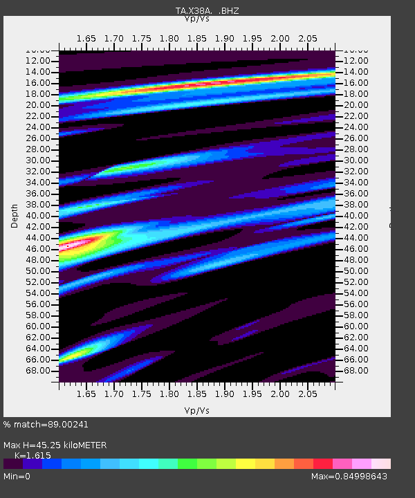
| Estimated Moho Depth: |
45.25 km |
| Estimated Crust Vp/Vs: |
1.62 |
| Assumed Crust Vp: |
6.498 km/s |
| Estimated Crust Vs: |
4.023 km/s |
| Estimated Crust Poisson's Ratio: |
0.19 |
|
| Radial Match: |
89.00241 % |
| Radial Bump: |
400 |
| Transverse Match: |
77.54767 % |
| Transverse Bump: |
400 |
| SOD ConfigId: |
414626 |
| Insert Time: |
2012-01-13 07:42:06.998 +0000 |
| GWidth: |
2.5 |
| Max Bumps: |
400 |
| Tol: |
0.001 |
|
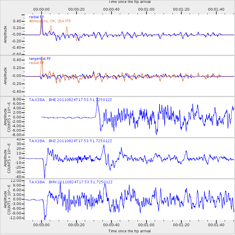
Signal To Noise
| Channel | StoN | STA | LTA |
| TA:X38A: :BHZ:20110824T17:53:51.725012Z | 55.592823 | 1.5508811E-5 | 2.7897144E-7 |
| TA:X38A: :BHN:20110824T17:53:51.725012Z | 24.508451 | 5.6601375E-6 | 2.3094636E-7 |
| TA:X38A: :BHE:20110824T17:53:51.725012Z | 23.692972 | 3.850768E-6 | 1.6252784E-7 |
| Arrivals |
| Ps | 4.6 SECOND |
| PpPs | 17 SECOND |
| PsPs/PpSs | 22 SECOND |


