You are here: Home > Network List > TA - USArray Transportable Network (new EarthScope stations) Stations List
> Station N33A J Bar K, Exeter, NE, USA > Earthquake Result Viewer
N33A J Bar K, Exeter, NE, USA - Earthquake Result Viewer
| Earthquake location: |
Peru-Brazil Border Region |
| Earthquake latitude/longitude: |
-7.6/-74.5 |
| Earthquake time(UTC): |
2011/08/24 (236) 17:46:11 GMT |
| Earthquake Depth: |
147 km |
| Earthquake Magnitude: |
6.8 MB, 7.0 MW, 7.0 MW |
| Earthquake Catalog/Contributor: |
WHDF/NEIC |
|
| Network: |
TA USArray Transportable Network (new EarthScope stations) |
| Station: |
N33A J Bar K, Exeter, NE, USA |
| Lat/Lon: |
40.74 N/97.45 W |
| Elevation: |
475 m |
|
| Distance: |
52.6 deg |
| Az: |
338.114 deg |
| Baz: |
150.905 deg |
| Ray Param: |
0.06617489 |
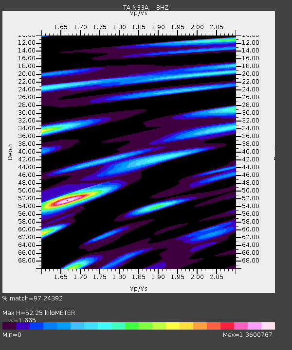
| Estimated Moho Depth: |
52.25 km |
| Estimated Crust Vp/Vs: |
1.66 |
| Assumed Crust Vp: |
6.498 km/s |
| Estimated Crust Vs: |
3.902 km/s |
| Estimated Crust Poisson's Ratio: |
0.22 |
|
| Radial Match: |
97.24392 % |
| Radial Bump: |
400 |
| Transverse Match: |
83.28207 % |
| Transverse Bump: |
400 |
| SOD ConfigId: |
414626 |
| Insert Time: |
2012-01-13 07:42:59.614 +0000 |
| GWidth: |
2.5 |
| Max Bumps: |
400 |
| Tol: |
0.001 |
|
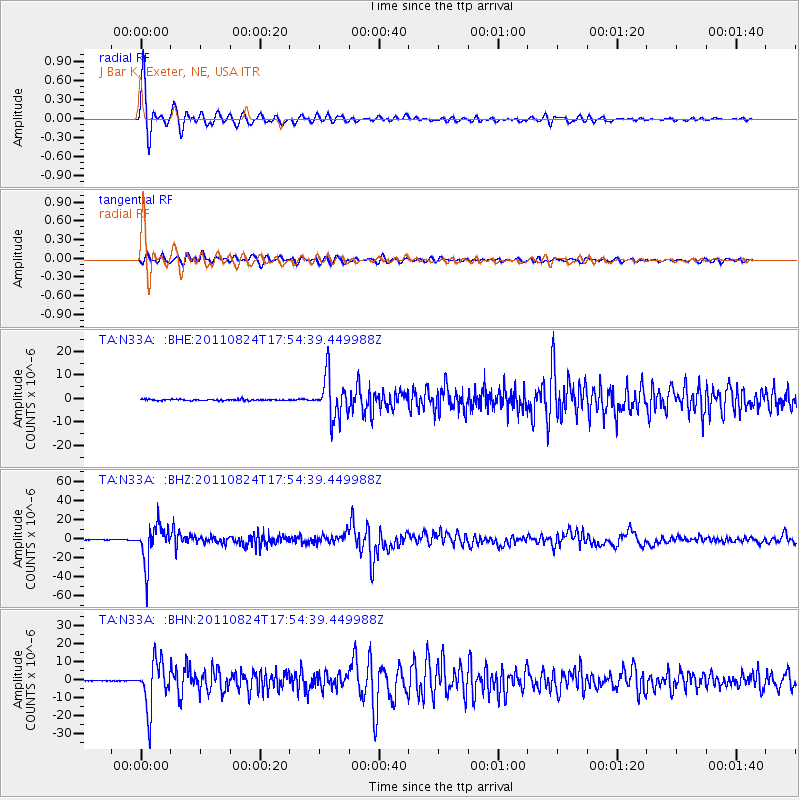
Signal To Noise
| Channel | StoN | STA | LTA |
| TA:N33A: :BHZ:20110824T17:54:39.449988Z | 145.70563 | 2.025728E-5 | 1.390288E-7 |
| TA:N33A: :BHN:20110824T17:54:39.449988Z | 72.8537 | 1.3196765E-5 | 1.8114063E-7 |
| TA:N33A: :BHE:20110824T17:54:39.449988Z | 34.90402 | 8.808023E-6 | 2.5234985E-7 |
| Arrivals |
| Ps | 5.7 SECOND |
| PpPs | 20 SECOND |
| PsPs/PpSs | 26 SECOND |


