You are here: Home > Network List > TA - USArray Transportable Network (new EarthScope stations) Stations List
> Station S37A Fort Scott, KS, USA > Earthquake Result Viewer
S37A Fort Scott, KS, USA - Earthquake Result Viewer
| Earthquake location: |
Peru-Brazil Border Region |
| Earthquake latitude/longitude: |
-7.6/-74.5 |
| Earthquake time(UTC): |
2011/08/24 (236) 17:46:11 GMT |
| Earthquake Depth: |
147 km |
| Earthquake Magnitude: |
6.8 MB, 7.0 MW, 7.0 MW |
| Earthquake Catalog/Contributor: |
WHDF/NEIC |
|
| Network: |
TA USArray Transportable Network (new EarthScope stations) |
| Station: |
S37A Fort Scott, KS, USA |
| Lat/Lon: |
37.76 N/94.83 W |
| Elevation: |
260 m |
|
| Distance: |
49.0 deg |
| Az: |
338.624 deg |
| Baz: |
152.881 deg |
| Ray Param: |
0.06848234 |
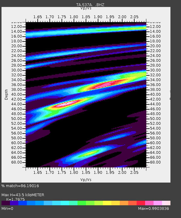
| Estimated Moho Depth: |
43.5 km |
| Estimated Crust Vp/Vs: |
1.77 |
| Assumed Crust Vp: |
6.53 km/s |
| Estimated Crust Vs: |
3.695 km/s |
| Estimated Crust Poisson's Ratio: |
0.26 |
|
| Radial Match: |
96.19016 % |
| Radial Bump: |
369 |
| Transverse Match: |
84.07933 % |
| Transverse Bump: |
400 |
| SOD ConfigId: |
414626 |
| Insert Time: |
2012-01-13 07:43:24.782 +0000 |
| GWidth: |
2.5 |
| Max Bumps: |
400 |
| Tol: |
0.001 |
|
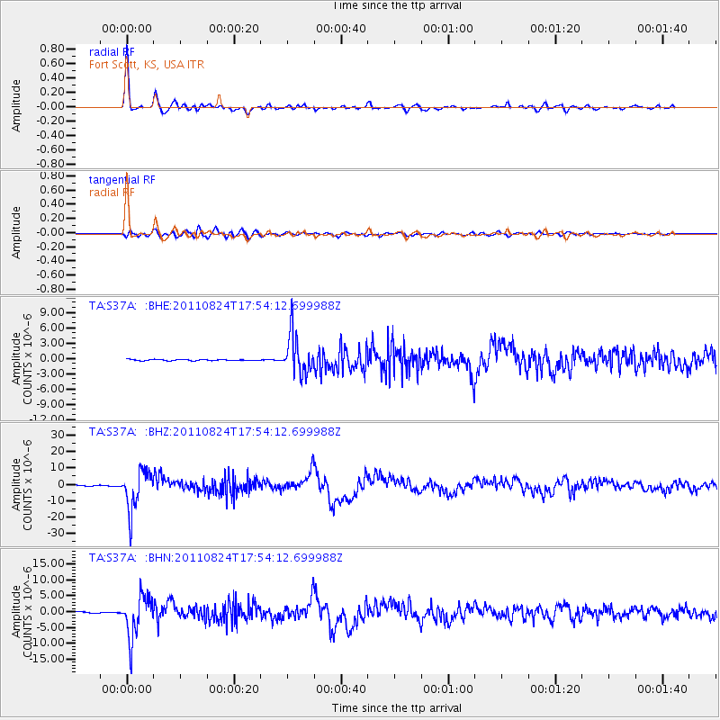
Signal To Noise
| Channel | StoN | STA | LTA |
| TA:S37A: :BHZ:20110824T17:54:12.699988Z | 61.468464 | 1.2282839E-5 | 1.9982342E-7 |
| TA:S37A: :BHN:20110824T17:54:12.699988Z | 37.06548 | 6.7246156E-6 | 1.8142529E-7 |
| TA:S37A: :BHE:20110824T17:54:12.699988Z | 34.975574 | 3.944648E-6 | 1.1278294E-7 |
| Arrivals |
| Ps | 5.4 SECOND |
| PpPs | 17 SECOND |
| PsPs/PpSs | 23 SECOND |


