You are here: Home > Network List > TA - USArray Transportable Network (new EarthScope stations) Stations List
> Station L04D Klamath Falls, OR, USA > Earthquake Result Viewer
L04D Klamath Falls, OR, USA - Earthquake Result Viewer
| Earthquake location: |
Peru-Brazil Border Region |
| Earthquake latitude/longitude: |
-7.6/-74.5 |
| Earthquake time(UTC): |
2011/08/24 (236) 17:46:11 GMT |
| Earthquake Depth: |
147 km |
| Earthquake Magnitude: |
6.8 MB, 7.0 MW, 7.0 MW |
| Earthquake Catalog/Contributor: |
WHDF/NEIC |
|
| Network: |
TA USArray Transportable Network (new EarthScope stations) |
| Station: |
L04D Klamath Falls, OR, USA |
| Lat/Lon: |
42.22 N/122.30 W |
| Elevation: |
1437 m |
|
| Distance: |
66.0 deg |
| Az: |
322.982 deg |
| Baz: |
126.544 deg |
| Ray Param: |
0.057473373 |
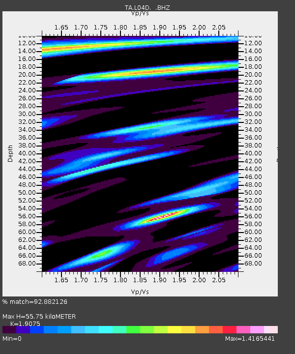
| Estimated Moho Depth: |
55.75 km |
| Estimated Crust Vp/Vs: |
1.91 |
| Assumed Crust Vp: |
6.522 km/s |
| Estimated Crust Vs: |
3.419 km/s |
| Estimated Crust Poisson's Ratio: |
0.31 |
|
| Radial Match: |
92.882126 % |
| Radial Bump: |
400 |
| Transverse Match: |
86.29674 % |
| Transverse Bump: |
400 |
| SOD ConfigId: |
414626 |
| Insert Time: |
2012-01-13 07:44:55.909 +0000 |
| GWidth: |
2.5 |
| Max Bumps: |
400 |
| Tol: |
0.001 |
|

Signal To Noise
| Channel | StoN | STA | LTA |
| TA:L04D: :BHZ:20110824T17:56:11.650Z | 73.76181 | 1.457327E-5 | 1.9757204E-7 |
| TA:L04D: :BHN:20110824T17:56:11.650Z | 13.221257 | 3.423666E-6 | 2.5895162E-7 |
| TA:L04D: :BHE:20110824T17:56:11.650Z | 12.005992 | 4.075685E-6 | 3.3947092E-7 |
| Arrivals |
| Ps | 8.1 SECOND |
| PpPs | 24 SECOND |
| PsPs/PpSs | 32 SECOND |


