You are here: Home > Network List > TA - USArray Transportable Network (new EarthScope stations) Stations List
> Station J01D Myrtle Point, OR, USA > Earthquake Result Viewer
J01D Myrtle Point, OR, USA - Earthquake Result Viewer

| Earthquake location: |
Peru-Brazil Border Region |
| Earthquake latitude/longitude: |
-7.6/-74.5 |
| Earthquake time(UTC): |
2011/08/24 (236) 17:46:11 GMT |
| Earthquake Depth: |
147 km |
| Earthquake Magnitude: |
6.8 MB, 7.0 MW, 7.0 MW |
| Earthquake Catalog/Contributor: |
WHDF/NEIC |
|
| Network: |
TA USArray Transportable Network (new EarthScope stations) |
| Station: |
J01D Myrtle Point, OR, USA |
| Lat/Lon: |
43.16 N/123.93 W |
| Elevation: |
131 m |
|
| Distance: |
67.5 deg |
| Az: |
323.044 deg |
| Baz: |
125.469 deg |
| Ray Param: |
0.056482762 |
| Estimated Moho Depth: |
13.25 km |
| Estimated Crust Vp/Vs: |
1.67 |
| Assumed Crust Vp: |
6.522 km/s |
| Estimated Crust Vs: |
3.911 km/s |
| Estimated Crust Poisson's Ratio: |
0.22 |
|
| Radial Match: |
93.35757 % |
| Radial Bump: |
400 |
| Transverse Match: |
87.96354 % |
| Transverse Bump: |
400 |
| SOD ConfigId: |
414626 |
| Insert Time: |
2012-01-13 07:45:12.900 +0000 |
| GWidth: |
2.5 |
| Max Bumps: |
400 |
| Tol: |
0.001 |
|
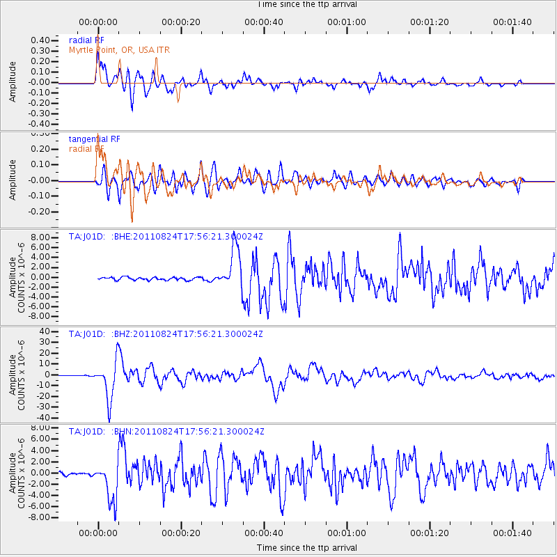
Signal To Noise
| Channel | StoN | STA | LTA |
| TA:J01D: :BHZ:20110824T17:56:21.300024Z | 85.80034 | 1.8192115E-5 | 2.1202847E-7 |
| TA:J01D: :BHN:20110824T17:56:21.300024Z | 13.916708 | 3.598853E-6 | 2.5859944E-7 |
| TA:J01D: :BHE:20110824T17:56:21.300024Z | 15.449418 | 4.425648E-6 | 2.864605E-7 |
| Arrivals |
| Ps | 1.4 SECOND |
| PpPs | 5.2 SECOND |
| PsPs/PpSs | 6.6 SECOND |


