You are here: Home > Network List > TA - USArray Transportable Network (new EarthScope stations) Stations List
> Station K37A Belmond, IA, USA > Earthquake Result Viewer
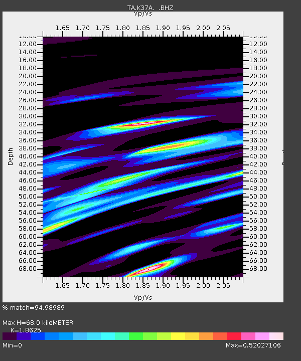
K37A Belmond, IA, USA - Earthquake Result Viewer
| Earthquake location: |
Peru-Brazil Border Region |
| Earthquake latitude/longitude: |
-7.6/-74.5 |
| Earthquake time(UTC): |
2011/08/24 (236) 17:46:11 GMT |
| Earthquake Depth: |
147 km |
| Earthquake Magnitude: |
6.8 MB, 7.0 MW, 7.0 MW |
| Earthquake Catalog/Contributor: |
WHDF/NEIC |
|
| Network: |
TA USArray Transportable Network (new EarthScope stations) |
| Station: |
K37A Belmond, IA, USA |
| Lat/Lon: |
42.77 N/93.64 W |
| Elevation: |
365 m |
|
| Distance: |
53.1 deg |
| Az: |
342.452 deg |
| Baz: |
156.056 deg |
| Ray Param: |
0.06581683 |
| Estimated Moho Depth: |
68.0 km |
| Estimated Crust Vp/Vs: |
1.86 |
| Assumed Crust Vp: |
6.53 km/s |
| Estimated Crust Vs: |
3.506 km/s |
| Estimated Crust Poisson's Ratio: |
0.30 |
|
| Radial Match: |
94.98989 % |
| Radial Bump: |
400 |
| Transverse Match: |
72.88647 % |
| Transverse Bump: |
400 |
| SOD ConfigId: |
414626 |
| Insert Time: |
2012-01-13 07:50:15.419 +0000 |
| GWidth: |
2.5 |
| Max Bumps: |
400 |
| Tol: |
0.001 |
|

Signal To Noise
| Channel | StoN | STA | LTA |
| TA:K37A: :BHZ:20110824T17:54:43.400Z | 67.82492 | 9.343811E-6 | 1.3776369E-7 |
| TA:K37A: :BHN:20110824T17:54:43.400Z | 34.698223 | 5.462827E-6 | 1.5743824E-7 |
| TA:K37A: :BHE:20110824T17:54:43.400Z | 19.715656 | 2.7055944E-6 | 1.3723076E-7 |
| Arrivals |
| Ps | 9.5 SECOND |
| PpPs | 28 SECOND |
| PsPs/PpSs | 38 SECOND |


