You are here: Home > Network List > TA - USArray Transportable Network (new EarthScope stations) Stations List
> Station R39A Chumby, Stover, MO, USA > Earthquake Result Viewer
R39A Chumby, Stover, MO, USA - Earthquake Result Viewer
| Earthquake location: |
Peru-Brazil Border Region |
| Earthquake latitude/longitude: |
-7.6/-74.5 |
| Earthquake time(UTC): |
2011/08/24 (236) 17:46:11 GMT |
| Earthquake Depth: |
147 km |
| Earthquake Magnitude: |
6.8 MB, 7.0 MW, 7.0 MW |
| Earthquake Catalog/Contributor: |
WHDF/NEIC |
|
| Network: |
TA USArray Transportable Network (new EarthScope stations) |
| Station: |
R39A Chumby, Stover, MO, USA |
| Lat/Lon: |
38.31 N/93.04 W |
| Elevation: |
290 m |
|
| Distance: |
48.9 deg |
| Az: |
340.631 deg |
| Baz: |
155.298 deg |
| Ray Param: |
0.0685578 |
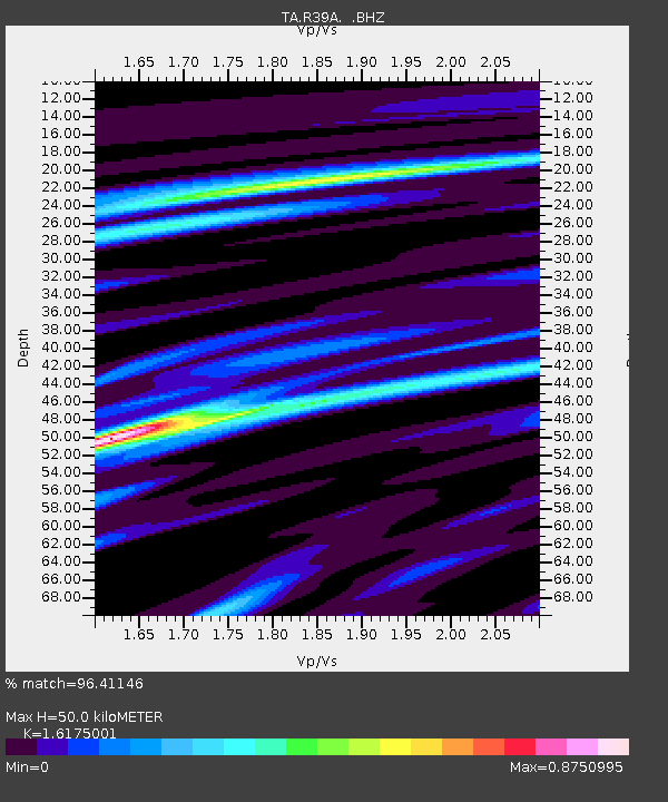
| Estimated Moho Depth: |
50.0 km |
| Estimated Crust Vp/Vs: |
1.62 |
| Assumed Crust Vp: |
6.498 km/s |
| Estimated Crust Vs: |
4.017 km/s |
| Estimated Crust Poisson's Ratio: |
0.19 |
|
| Radial Match: |
96.41146 % |
| Radial Bump: |
356 |
| Transverse Match: |
83.563286 % |
| Transverse Bump: |
400 |
| SOD ConfigId: |
414626 |
| Insert Time: |
2012-01-13 07:53:12.871 +0000 |
| GWidth: |
2.5 |
| Max Bumps: |
400 |
| Tol: |
0.001 |
|
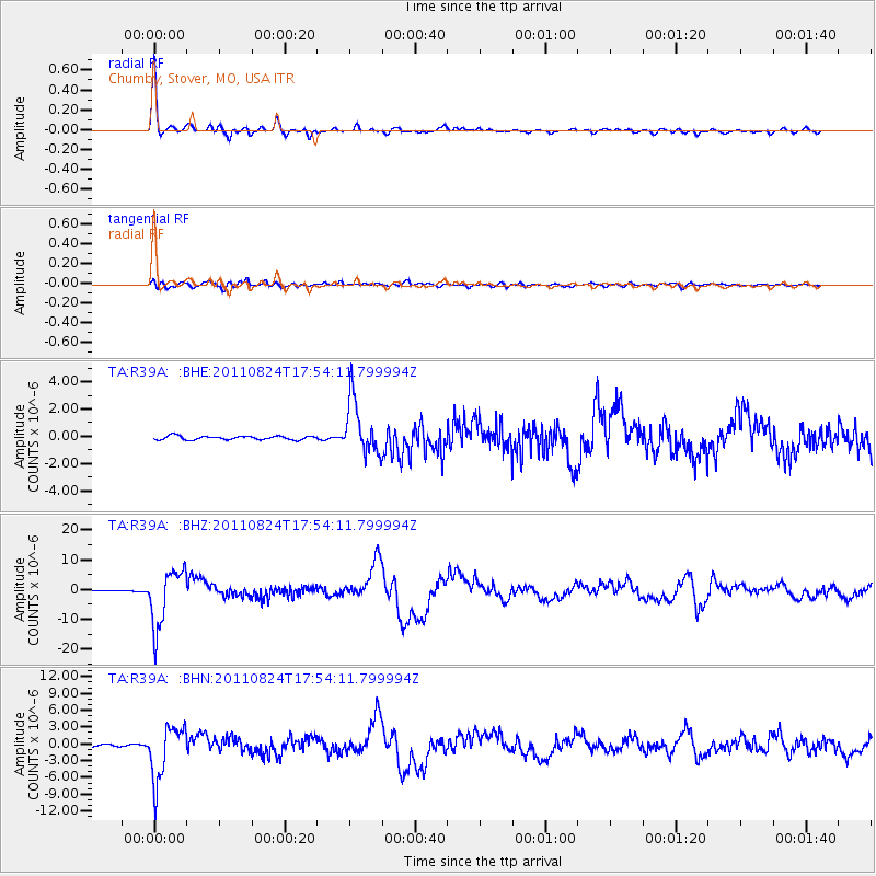
Signal To Noise
| Channel | StoN | STA | LTA |
| TA:R39A: :BHZ:20110824T17:54:11.799994Z | 61.99864 | 9.4978395E-6 | 1.5319434E-7 |
| TA:R39A: :BHN:20110824T17:54:11.799994Z | 28.07737 | 4.825046E-6 | 1.7184821E-7 |
| TA:R39A: :BHE:20110824T17:54:11.799994Z | 14.334495 | 1.980256E-6 | 1.381462E-7 |
| Arrivals |
| Ps | 5.1 SECOND |
| PpPs | 19 SECOND |
| PsPs/PpSs | 24 SECOND |


