You are here: Home > Network List > TA - USArray Transportable Network (new EarthScope stations) Stations List
> Station 142A Monroe, LA, USA > Earthquake Result Viewer
142A Monroe, LA, USA - Earthquake Result Viewer

| Earthquake location: |
Peru-Brazil Border Region |
| Earthquake latitude/longitude: |
-7.6/-74.5 |
| Earthquake time(UTC): |
2011/08/24 (236) 17:46:11 GMT |
| Earthquake Depth: |
147 km |
| Earthquake Magnitude: |
6.8 MB, 7.0 MW, 7.0 MW |
| Earthquake Catalog/Contributor: |
WHDF/NEIC |
|
| Network: |
TA USArray Transportable Network (new EarthScope stations) |
| Station: |
142A Monroe, LA, USA |
| Lat/Lon: |
32.55 N/91.95 W |
| Elevation: |
23 m |
|
| Distance: |
43.3 deg |
| Az: |
338.356 deg |
| Baz: |
154.349 deg |
| Ray Param: |
0.0721018 |
| Estimated Moho Depth: |
12.75 km |
| Estimated Crust Vp/Vs: |
1.60 |
| Assumed Crust Vp: |
6.201 km/s |
| Estimated Crust Vs: |
3.876 km/s |
| Estimated Crust Poisson's Ratio: |
0.18 |
|
| Radial Match: |
90.24375 % |
| Radial Bump: |
370 |
| Transverse Match: |
77.71099 % |
| Transverse Bump: |
400 |
| SOD ConfigId: |
414626 |
| Insert Time: |
2012-01-13 07:55:41.413 +0000 |
| GWidth: |
2.5 |
| Max Bumps: |
400 |
| Tol: |
0.001 |
|
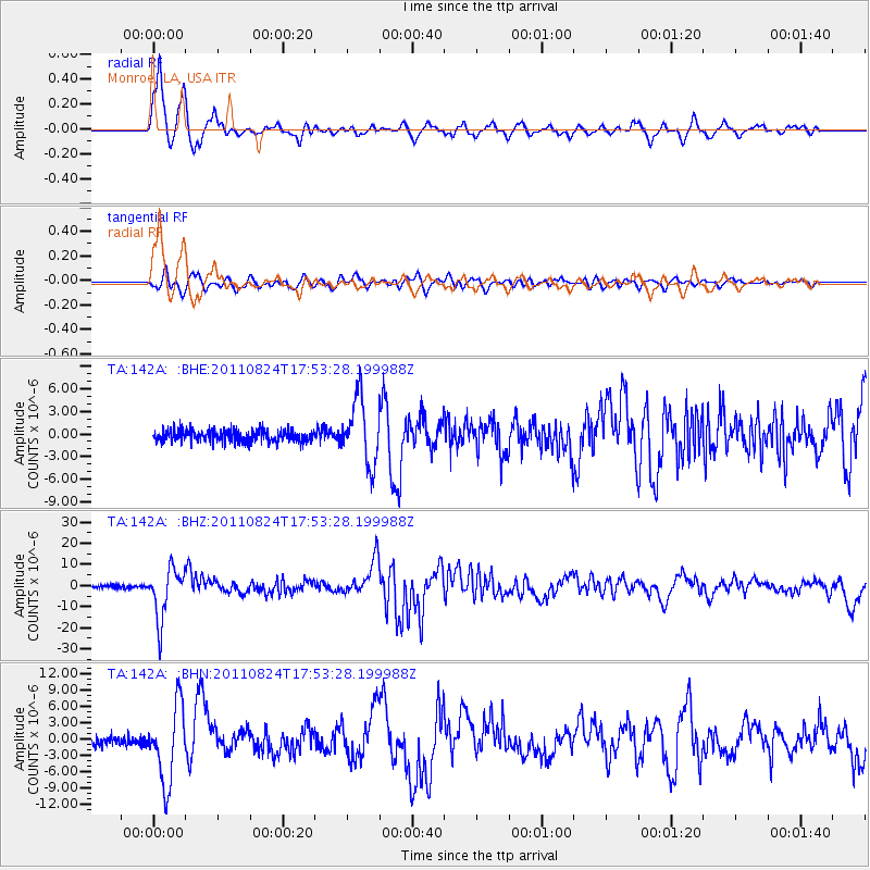
Signal To Noise
| Channel | StoN | STA | LTA |
| TA:142A: :BHZ:20110824T17:53:28.199988Z | 21.759686 | 1.2028674E-5 | 5.5279634E-7 |
| TA:142A: :BHN:20110824T17:53:28.199988Z | 9.488746 | 7.0405727E-6 | 7.419919E-7 |
| TA:142A: :BHE:20110824T17:53:28.199988Z | 5.4125133 | 4.26543E-6 | 7.880683E-7 |
| Arrivals |
| Ps | 1.3 SECOND |
| PpPs | 5.0 SECOND |
| PsPs/PpSs | 6.3 SECOND |


