You are here: Home > Network List > TA - USArray Transportable Network (new EarthScope stations) Stations List
> Station V40A Witts Springs, AR, USA > Earthquake Result Viewer
V40A Witts Springs, AR, USA - Earthquake Result Viewer
| Earthquake location: |
Peru-Brazil Border Region |
| Earthquake latitude/longitude: |
-7.6/-74.5 |
| Earthquake time(UTC): |
2011/08/24 (236) 17:46:11 GMT |
| Earthquake Depth: |
147 km |
| Earthquake Magnitude: |
6.8 MB, 7.0 MW, 7.0 MW |
| Earthquake Catalog/Contributor: |
WHDF/NEIC |
|
| Network: |
TA USArray Transportable Network (new EarthScope stations) |
| Station: |
V40A Witts Springs, AR, USA |
| Lat/Lon: |
35.80 N/92.82 W |
| Elevation: |
570 m |
|
| Distance: |
46.5 deg |
| Az: |
339.408 deg |
| Baz: |
154.603 deg |
| Ray Param: |
0.07005153 |
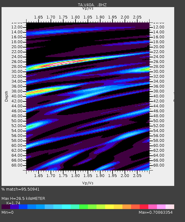
| Estimated Moho Depth: |
26.5 km |
| Estimated Crust Vp/Vs: |
1.74 |
| Assumed Crust Vp: |
6.498 km/s |
| Estimated Crust Vs: |
3.734 km/s |
| Estimated Crust Poisson's Ratio: |
0.25 |
|
| Radial Match: |
95.50941 % |
| Radial Bump: |
386 |
| Transverse Match: |
70.63816 % |
| Transverse Bump: |
400 |
| SOD ConfigId: |
414626 |
| Insert Time: |
2012-01-13 07:55:59.009 +0000 |
| GWidth: |
2.5 |
| Max Bumps: |
400 |
| Tol: |
0.001 |
|

Signal To Noise
| Channel | StoN | STA | LTA |
| TA:V40A: :BHZ:20110824T17:53:53.799994Z | 94.77072 | 1.152183E-5 | 1.2157584E-7 |
| TA:V40A: :BHN:20110824T17:53:53.799994Z | 37.84097 | 6.4446413E-6 | 1.7030857E-7 |
| TA:V40A: :BHE:20110824T17:53:53.799994Z | 36.899815 | 3.6772772E-6 | 9.965571E-8 |
| Arrivals |
| Ps | 3.2 SECOND |
| PpPs | 10 SECOND |
| PsPs/PpSs | 14 SECOND |


