You are here: Home > Network List > TA - USArray Transportable Network (new EarthScope stations) Stations List
> Station 341A Kurthwood, LA, USA > Earthquake Result Viewer
341A Kurthwood, LA, USA - Earthquake Result Viewer
| Earthquake location: |
Peru-Brazil Border Region |
| Earthquake latitude/longitude: |
-7.6/-74.5 |
| Earthquake time(UTC): |
2011/08/24 (236) 17:46:11 GMT |
| Earthquake Depth: |
147 km |
| Earthquake Magnitude: |
6.8 MB, 7.0 MW, 7.0 MW |
| Earthquake Catalog/Contributor: |
WHDF/NEIC |
|
| Network: |
TA USArray Transportable Network (new EarthScope stations) |
| Station: |
341A Kurthwood, LA, USA |
| Lat/Lon: |
31.33 N/93.17 W |
| Elevation: |
93 m |
|
| Distance: |
42.7 deg |
| Az: |
336.194 deg |
| Baz: |
152.123 deg |
| Ray Param: |
0.0724934 |
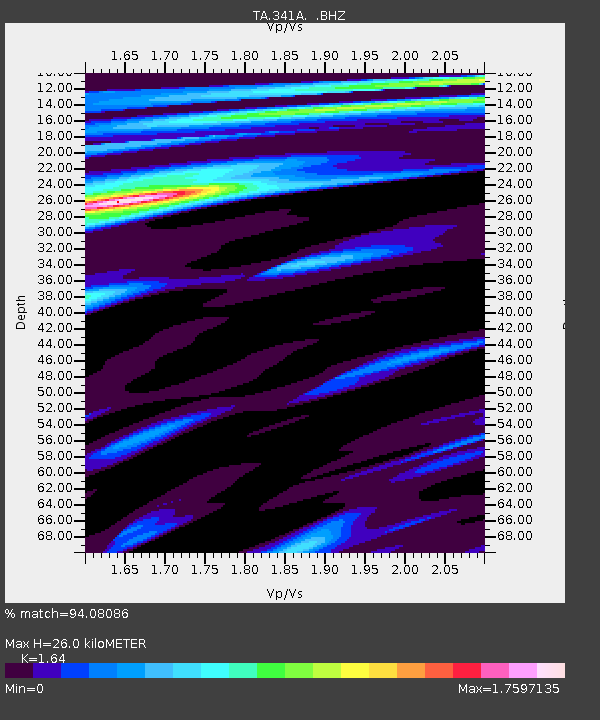
| Estimated Moho Depth: |
26.0 km |
| Estimated Crust Vp/Vs: |
1.64 |
| Assumed Crust Vp: |
6.065 km/s |
| Estimated Crust Vs: |
3.698 km/s |
| Estimated Crust Poisson's Ratio: |
0.20 |
|
| Radial Match: |
94.08086 % |
| Radial Bump: |
372 |
| Transverse Match: |
78.36412 % |
| Transverse Bump: |
400 |
| SOD ConfigId: |
414626 |
| Insert Time: |
2012-01-13 07:56:21.045 +0000 |
| GWidth: |
2.5 |
| Max Bumps: |
400 |
| Tol: |
0.001 |
|
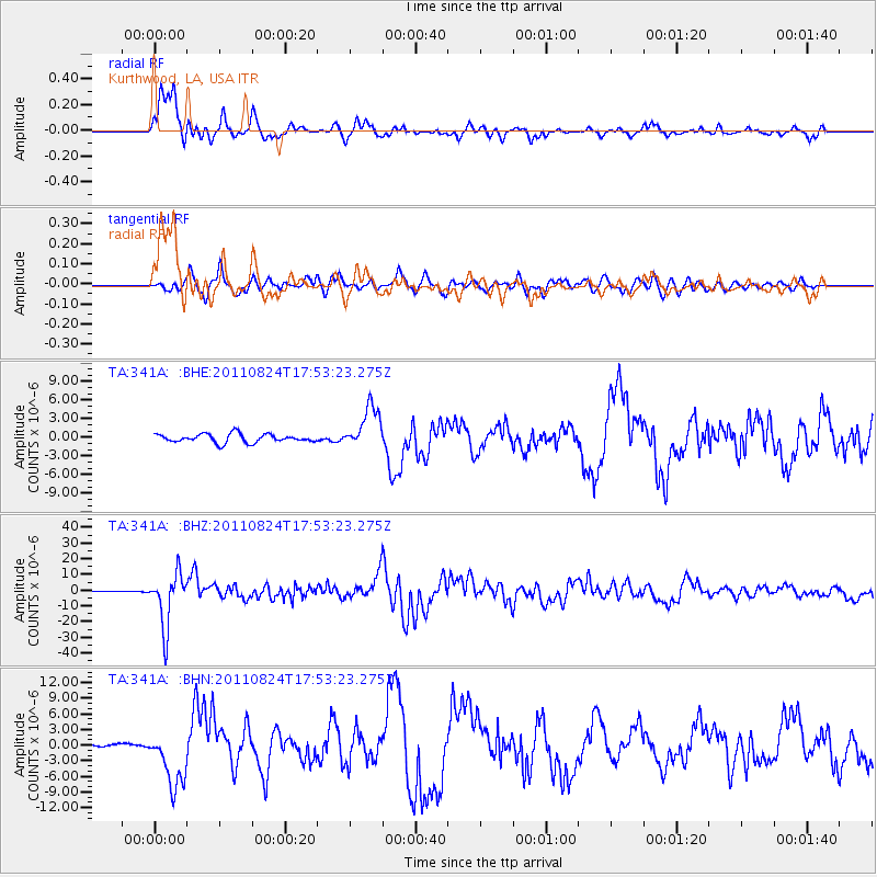
Signal To Noise
| Channel | StoN | STA | LTA |
| TA:341A: :BHZ:20110824T17:53:23.275Z | 69.05136 | 1.6987124E-5 | 2.460071E-7 |
| TA:341A: :BHN:20110824T17:53:23.275Z | 12.552412 | 5.670062E-6 | 4.5171095E-7 |
| TA:341A: :BHE:20110824T17:53:23.275Z | 4.956969 | 3.387465E-6 | 6.833743E-7 |
| Arrivals |
| Ps | 2.9 SECOND |
| PpPs | 11 SECOND |
| PsPs/PpSs | 14 SECOND |


