You are here: Home > Network List > TA - USArray Transportable Network (new EarthScope stations) Stations List
> Station Y46A Houston, MS, USA > Earthquake Result Viewer
Y46A Houston, MS, USA - Earthquake Result Viewer

| Earthquake location: |
Peru-Brazil Border Region |
| Earthquake latitude/longitude: |
-7.6/-74.5 |
| Earthquake time(UTC): |
2011/08/24 (236) 17:46:11 GMT |
| Earthquake Depth: |
147 km |
| Earthquake Magnitude: |
6.8 MB, 7.0 MW, 7.0 MW |
| Earthquake Catalog/Contributor: |
WHDF/NEIC |
|
| Network: |
TA USArray Transportable Network (new EarthScope stations) |
| Station: |
Y46A Houston, MS, USA |
| Lat/Lon: |
33.88 N/88.86 W |
| Elevation: |
109 m |
|
| Distance: |
43.5 deg |
| Az: |
342.584 deg |
| Baz: |
159.107 deg |
| Ray Param: |
0.07198054 |
| Estimated Moho Depth: |
43.5 km |
| Estimated Crust Vp/Vs: |
1.81 |
| Assumed Crust Vp: |
6.201 km/s |
| Estimated Crust Vs: |
3.431 km/s |
| Estimated Crust Poisson's Ratio: |
0.28 |
|
| Radial Match: |
95.27398 % |
| Radial Bump: |
328 |
| Transverse Match: |
86.84778 % |
| Transverse Bump: |
400 |
| SOD ConfigId: |
414626 |
| Insert Time: |
2012-01-13 07:59:09.683 +0000 |
| GWidth: |
2.5 |
| Max Bumps: |
400 |
| Tol: |
0.001 |
|
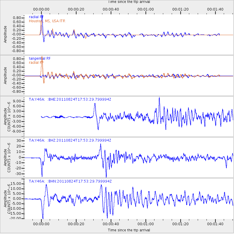
Signal To Noise
| Channel | StoN | STA | LTA |
| TA:Y46A: :BHZ:20110824T17:53:29.799994Z | 90.65438 | 1.22123665E-5 | 1.3471347E-7 |
| TA:Y46A: :BHN:20110824T17:53:29.799994Z | 57.998127 | 9.011019E-6 | 1.5536742E-7 |
| TA:Y46A: :BHE:20110824T17:53:29.799994Z | 14.942774 | 3.8286E-6 | 2.5621748E-7 |
| Arrivals |
| Ps | 6.0 SECOND |
| PpPs | 19 SECOND |
| PsPs/PpSs | 25 SECOND |


