You are here: Home > Network List > TA - USArray Transportable Network (new EarthScope stations) Stations List
> Station O42A Bath, IL, USA > Earthquake Result Viewer
O42A Bath, IL, USA - Earthquake Result Viewer
| Earthquake location: |
Peru-Brazil Border Region |
| Earthquake latitude/longitude: |
-7.6/-74.5 |
| Earthquake time(UTC): |
2011/08/24 (236) 17:46:11 GMT |
| Earthquake Depth: |
147 km |
| Earthquake Magnitude: |
6.8 MB, 7.0 MW, 7.0 MW |
| Earthquake Catalog/Contributor: |
WHDF/NEIC |
|
| Network: |
TA USArray Transportable Network (new EarthScope stations) |
| Station: |
O42A Bath, IL, USA |
| Lat/Lon: |
40.20 N/90.08 W |
| Elevation: |
155 m |
|
| Distance: |
49.7 deg |
| Az: |
344.379 deg |
| Baz: |
159.607 deg |
| Ray Param: |
0.06801018 |
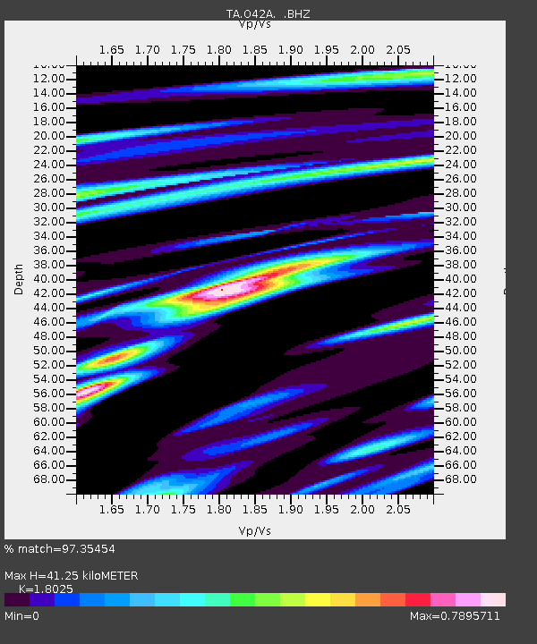
| Estimated Moho Depth: |
41.25 km |
| Estimated Crust Vp/Vs: |
1.80 |
| Assumed Crust Vp: |
6.498 km/s |
| Estimated Crust Vs: |
3.605 km/s |
| Estimated Crust Poisson's Ratio: |
0.28 |
|
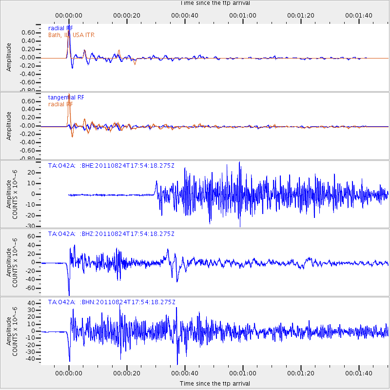
| Radial Match: |
97.35454 % |
| Radial Bump: |
324 |
| Transverse Match: |
88.960464 % |
| Transverse Bump: |
400 |
| SOD ConfigId: |
414626 |
| Insert Time: |
2012-01-13 08:26:16.067 +0000 |
| GWidth: |
2.5 |
| Max Bumps: |
400 |
| Tol: |
0.001 |
|
Signal To Noise
| Channel | StoN | STA | LTA |
| TA:O42A: :BHZ:20110824T17:54:18.275Z | 112.69054 | 2.3807213E-5 | 2.1126188E-7 |
| TA:O42A: :BHN:20110824T17:54:18.275Z | 57.726936 | 1.4916089E-5 | 2.5839043E-7 |
| TA:O42A: :BHE:20110824T17:54:18.275Z | 29.945312 | 6.239455E-6 | 2.0836168E-7 |
| Arrivals |
| Ps | 5.4 SECOND |
| PpPs | 17 SECOND |
| PsPs/PpSs | 22 SECOND |


