You are here: Home > Network List > TA - USArray Transportable Network (new EarthScope stations) Stations List
> Station S42A Caledonia, MO, USA > Earthquake Result Viewer
S42A Caledonia, MO, USA - Earthquake Result Viewer
| Earthquake location: |
Peru-Brazil Border Region |
| Earthquake latitude/longitude: |
-7.6/-74.5 |
| Earthquake time(UTC): |
2011/08/24 (236) 17:46:11 GMT |
| Earthquake Depth: |
147 km |
| Earthquake Magnitude: |
6.8 MB, 7.0 MW, 7.0 MW |
| Earthquake Catalog/Contributor: |
WHDF/NEIC |
|
| Network: |
TA USArray Transportable Network (new EarthScope stations) |
| Station: |
S42A Caledonia, MO, USA |
| Lat/Lon: |
37.77 N/90.79 W |
| Elevation: |
315 m |
|
| Distance: |
47.7 deg |
| Az: |
342.522 deg |
| Baz: |
157.934 deg |
| Ray Param: |
0.06933847 |
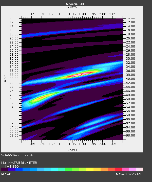
| Estimated Moho Depth: |
37.5 km |
| Estimated Crust Vp/Vs: |
1.89 |
| Assumed Crust Vp: |
6.53 km/s |
| Estimated Crust Vs: |
3.446 km/s |
| Estimated Crust Poisson's Ratio: |
0.31 |
|
| Radial Match: |
93.67254 % |
| Radial Bump: |
215 |
| Transverse Match: |
69.71347 % |
| Transverse Bump: |
400 |
| SOD ConfigId: |
414626 |
| Insert Time: |
2012-01-13 08:27:22.256 +0000 |
| GWidth: |
2.5 |
| Max Bumps: |
400 |
| Tol: |
0.001 |
|

Signal To Noise
| Channel | StoN | STA | LTA |
| TA:S42A: :BHZ:20110824T17:54:02.600012Z | 41.255062 | 7.72629E-6 | 1.8728103E-7 |
| TA:S42A: :BHN:20110824T17:54:02.600012Z | 21.100513 | 4.338136E-6 | 2.0559385E-7 |
| TA:S42A: :BHE:20110824T17:54:02.600012Z | 8.589649 | 1.6752357E-6 | 1.9502959E-7 |
| Arrivals |
| Ps | 5.4 SECOND |
| PpPs | 16 SECOND |
| PsPs/PpSs | 21 SECOND |


