You are here: Home > Network List > TA - USArray Transportable Network (new EarthScope stations) Stations List
> Station V43A Jonesboro, AR, USA > Earthquake Result Viewer
V43A Jonesboro, AR, USA - Earthquake Result Viewer
| Earthquake location: |
Peru-Brazil Border Region |
| Earthquake latitude/longitude: |
-7.6/-74.5 |
| Earthquake time(UTC): |
2011/08/24 (236) 17:46:11 GMT |
| Earthquake Depth: |
147 km |
| Earthquake Magnitude: |
6.8 MB, 7.0 MW, 7.0 MW |
| Earthquake Catalog/Contributor: |
WHDF/NEIC |
|
| Network: |
TA USArray Transportable Network (new EarthScope stations) |
| Station: |
V43A Jonesboro, AR, USA |
| Lat/Lon: |
35.79 N/90.54 W |
| Elevation: |
74 m |
|
| Distance: |
45.8 deg |
| Az: |
341.746 deg |
| Baz: |
157.551 deg |
| Ray Param: |
0.07055282 |
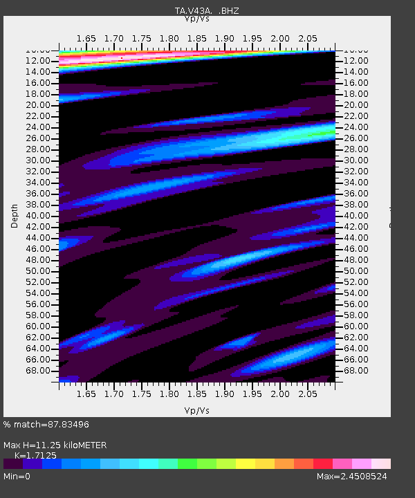
| Estimated Moho Depth: |
11.25 km |
| Estimated Crust Vp/Vs: |
1.71 |
| Assumed Crust Vp: |
6.273 km/s |
| Estimated Crust Vs: |
3.663 km/s |
| Estimated Crust Poisson's Ratio: |
0.24 |
|
| Radial Match: |
87.83496 % |
| Radial Bump: |
400 |
| Transverse Match: |
72.71929 % |
| Transverse Bump: |
400 |
| SOD ConfigId: |
414626 |
| Insert Time: |
2012-01-13 08:28:00.432 +0000 |
| GWidth: |
2.5 |
| Max Bumps: |
400 |
| Tol: |
0.001 |
|

Signal To Noise
| Channel | StoN | STA | LTA |
| TA:V43A: :BHZ:20110824T17:53:47.799994Z | 32.913483 | 1.298797E-5 | 3.9460943E-7 |
| TA:V43A: :BHN:20110824T17:53:47.799994Z | 19.647308 | 9.19813E-6 | 4.6816237E-7 |
| TA:V43A: :BHE:20110824T17:53:47.799994Z | 7.515413 | 4.6837617E-6 | 6.2322084E-7 |
| Arrivals |
| Ps | 1.4 SECOND |
| PpPs | 4.6 SECOND |
| PsPs/PpSs | 5.9 SECOND |


