You are here: Home > Network List > TA - USArray Transportable Network (new EarthScope stations) Stations List
> Station M41A Milan, IL, USA > Earthquake Result Viewer
M41A Milan, IL, USA - Earthquake Result Viewer
| Earthquake location: |
Peru-Brazil Border Region |
| Earthquake latitude/longitude: |
-7.6/-74.5 |
| Earthquake time(UTC): |
2011/08/24 (236) 17:46:11 GMT |
| Earthquake Depth: |
147 km |
| Earthquake Magnitude: |
6.8 MB, 7.0 MW, 7.0 MW |
| Earthquake Catalog/Contributor: |
WHDF/NEIC |
|
| Network: |
TA USArray Transportable Network (new EarthScope stations) |
| Station: |
M41A Milan, IL, USA |
| Lat/Lon: |
41.38 N/90.54 W |
| Elevation: |
226 m |
|
| Distance: |
50.9 deg |
| Az: |
344.489 deg |
| Baz: |
159.377 deg |
| Ray Param: |
0.06722792 |
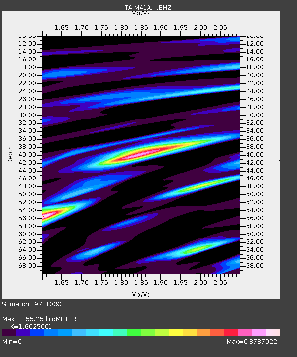
| Estimated Moho Depth: |
55.25 km |
| Estimated Crust Vp/Vs: |
1.60 |
| Assumed Crust Vp: |
6.498 km/s |
| Estimated Crust Vs: |
4.055 km/s |
| Estimated Crust Poisson's Ratio: |
0.18 |
|
| Radial Match: |
97.30093 % |
| Radial Bump: |
301 |
| Transverse Match: |
91.33391 % |
| Transverse Bump: |
400 |
| SOD ConfigId: |
414626 |
| Insert Time: |
2012-01-13 08:28:36.565 +0000 |
| GWidth: |
2.5 |
| Max Bumps: |
400 |
| Tol: |
0.001 |
|

Signal To Noise
| Channel | StoN | STA | LTA |
| TA:M41A: :BHZ:20110824T17:54:27.475012Z | 60.091476 | 1.5375539E-5 | 2.5586888E-7 |
| TA:M41A: :BHN:20110824T17:54:27.475012Z | 38.057438 | 1.0057103E-5 | 2.6426116E-7 |
| TA:M41A: :BHE:20110824T17:54:27.475012Z | 20.799004 | 5.415617E-6 | 2.6037867E-7 |
| Arrivals |
| Ps | 5.5 SECOND |
| PpPs | 21 SECOND |
| PsPs/PpSs | 26 SECOND |


