You are here: Home > Network List > TA - USArray Transportable Network (new EarthScope stations) Stations List
> Station U44B Burton Farm, Hornbeak, TN, USA > Earthquake Result Viewer
U44B Burton Farm, Hornbeak, TN, USA - Earthquake Result Viewer
| Earthquake location: |
Peru-Brazil Border Region |
| Earthquake latitude/longitude: |
-7.6/-74.5 |
| Earthquake time(UTC): |
2011/08/24 (236) 17:46:11 GMT |
| Earthquake Depth: |
147 km |
| Earthquake Magnitude: |
6.8 MB, 7.0 MW, 7.0 MW |
| Earthquake Catalog/Contributor: |
WHDF/NEIC |
|
| Network: |
TA USArray Transportable Network (new EarthScope stations) |
| Station: |
U44B Burton Farm, Hornbeak, TN, USA |
| Lat/Lon: |
36.34 N/89.35 W |
| Elevation: |
136 m |
|
| Distance: |
45.9 deg |
| Az: |
343.283 deg |
| Baz: |
159.321 deg |
| Ray Param: |
0.07045353 |
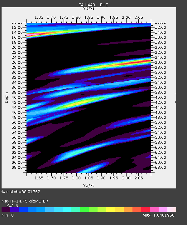
| Estimated Moho Depth: |
14.75 km |
| Estimated Crust Vp/Vs: |
1.60 |
| Assumed Crust Vp: |
6.444 km/s |
| Estimated Crust Vs: |
4.027 km/s |
| Estimated Crust Poisson's Ratio: |
0.18 |
|
| Radial Match: |
88.01762 % |
| Radial Bump: |
400 |
| Transverse Match: |
76.4217 % |
| Transverse Bump: |
400 |
| SOD ConfigId: |
414626 |
| Insert Time: |
2012-01-13 08:29:17.760 +0000 |
| GWidth: |
2.5 |
| Max Bumps: |
400 |
| Tol: |
0.001 |
|

Signal To Noise
| Channel | StoN | STA | LTA |
| TA:U44B: :BHZ:20110824T17:53:49.025Z | 38.892796 | 1.2341075E-5 | 3.1731005E-7 |
| TA:U44B: :BHN:20110824T17:53:49.025Z | 13.448251 | 1.3102785E-5 | 9.743114E-7 |
| TA:U44B: :BHE:20110824T17:53:49.025Z | 8.226763 | 5.3640297E-6 | 6.520219E-7 |
| Arrivals |
| Ps | 1.5 SECOND |
| PpPs | 5.6 SECOND |
| PsPs/PpSs | 7.0 SECOND |


