You are here: Home > Network List > TA - USArray Transportable Network (new EarthScope stations) Stations List
> Station U45A Rockin P Farm, Martin, TN, USA > Earthquake Result Viewer
U45A Rockin P Farm, Martin, TN, USA - Earthquake Result Viewer
| Earthquake location: |
Peru-Brazil Border Region |
| Earthquake latitude/longitude: |
-7.6/-74.5 |
| Earthquake time(UTC): |
2011/08/24 (236) 17:46:11 GMT |
| Earthquake Depth: |
147 km |
| Earthquake Magnitude: |
6.8 MB, 7.0 MW, 7.0 MW |
| Earthquake Catalog/Contributor: |
WHDF/NEIC |
|
| Network: |
TA USArray Transportable Network (new EarthScope stations) |
| Station: |
U45A Rockin P Farm, Martin, TN, USA |
| Lat/Lon: |
36.35 N/88.76 W |
| Elevation: |
144 m |
|
| Distance: |
45.8 deg |
| Az: |
343.908 deg |
| Baz: |
160.103 deg |
| Ray Param: |
0.070551485 |
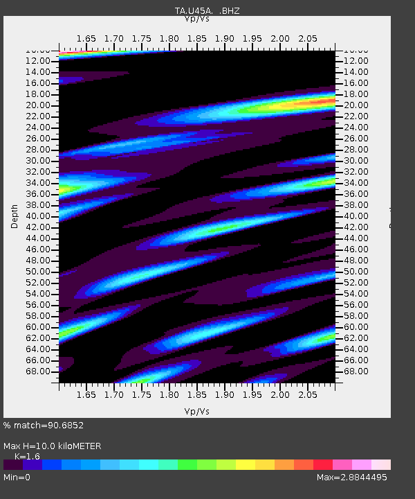
| Estimated Moho Depth: |
10.0 km |
| Estimated Crust Vp/Vs: |
1.60 |
| Assumed Crust Vp: |
6.444 km/s |
| Estimated Crust Vs: |
4.027 km/s |
| Estimated Crust Poisson's Ratio: |
0.18 |
|
| Radial Match: |
90.6852 % |
| Radial Bump: |
400 |
| Transverse Match: |
83.15902 % |
| Transverse Bump: |
400 |
| SOD ConfigId: |
414626 |
| Insert Time: |
2012-01-13 08:29:36.634 +0000 |
| GWidth: |
2.5 |
| Max Bumps: |
400 |
| Tol: |
0.001 |
|

Signal To Noise
| Channel | StoN | STA | LTA |
| TA:U45A: :BHZ:20110824T17:53:47.824988Z | 47.12309 | 1.03878965E-5 | 2.2044176E-7 |
| TA:U45A: :BHN:20110824T17:53:47.824988Z | 20.475088 | 9.367099E-6 | 4.574876E-7 |
| TA:U45A: :BHE:20110824T17:53:47.824988Z | 13.31417 | 3.7439022E-6 | 2.811968E-7 |
| Arrivals |
| Ps | 1.0 SECOND |
| PpPs | 3.8 SECOND |
| PsPs/PpSs | 4.8 SECOND |


