You are here: Home > Network List > TA - USArray Transportable Network (new EarthScope stations) Stations List
> Station O43A Sugar Creek Farm, Atlanta, IL, USA > Earthquake Result Viewer
O43A Sugar Creek Farm, Atlanta, IL, USA - Earthquake Result Viewer
| Earthquake location: |
Peru-Brazil Border Region |
| Earthquake latitude/longitude: |
-7.6/-74.5 |
| Earthquake time(UTC): |
2011/08/24 (236) 17:46:11 GMT |
| Earthquake Depth: |
147 km |
| Earthquake Magnitude: |
6.8 MB, 7.0 MW, 7.0 MW |
| Earthquake Catalog/Contributor: |
WHDF/NEIC |
|
| Network: |
TA USArray Transportable Network (new EarthScope stations) |
| Station: |
O43A Sugar Creek Farm, Atlanta, IL, USA |
| Lat/Lon: |
40.29 N/89.31 W |
| Elevation: |
224 m |
|
| Distance: |
49.6 deg |
| Az: |
345.145 deg |
| Baz: |
160.597 deg |
| Ray Param: |
0.06808711 |
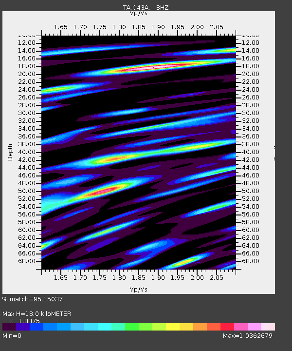
| Estimated Moho Depth: |
18.0 km |
| Estimated Crust Vp/Vs: |
1.89 |
| Assumed Crust Vp: |
6.498 km/s |
| Estimated Crust Vs: |
3.442 km/s |
| Estimated Crust Poisson's Ratio: |
0.30 |
|
| Radial Match: |
95.15037 % |
| Radial Bump: |
400 |
| Transverse Match: |
83.93347 % |
| Transverse Bump: |
400 |
| SOD ConfigId: |
414626 |
| Insert Time: |
2012-01-13 08:30:50.287 +0000 |
| GWidth: |
2.5 |
| Max Bumps: |
400 |
| Tol: |
0.001 |
|
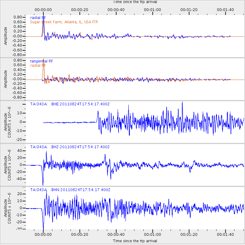
Signal To Noise
| Channel | StoN | STA | LTA |
| TA:O43A: :BHZ:20110824T17:54:17.400Z | 80.494965 | 1.8126342E-5 | 2.2518601E-7 |
| TA:O43A: :BHN:20110824T17:54:17.400Z | 41.1163 | 1.2202693E-5 | 2.9678483E-7 |
| TA:O43A: :BHE:20110824T17:54:17.400Z | 25.951944 | 5.5728206E-6 | 2.1473615E-7 |
| Arrivals |
| Ps | 2.6 SECOND |
| PpPs | 7.6 SECOND |
| PsPs/PpSs | 10 SECOND |


