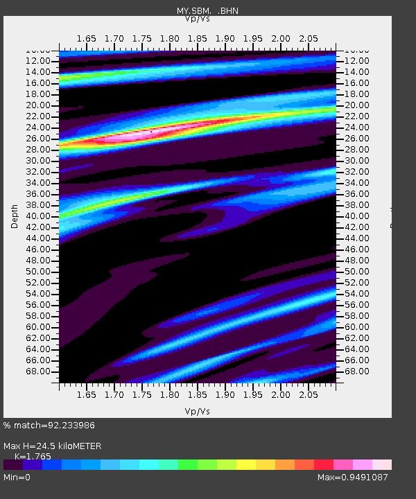
SBM Sibu - Earthquake Result Viewer

Earthquake location: Vanuatu Islands
Earthquake latitude/longitude: -18.2/167.7
Earthquake time(UTC): 2011/08/24 (236) 23:06:17 GMT
Earthquake Depth: 13 km
Earthquake Magnitude: 5.7 MB, 6.0 MS, 6.2 MW, 6.1 MW
Earthquake Catalog/Contributor: WHDF/NEIC
Network: MY Malaysian National Seismic Network
Station: SBM Sibu
Lat/Lon: 2.45 N/112.21 E
Elevation: 237 m
Distance: 58.4 deg
Az: 284.673 deg
Baz: 112.978 deg
Ray Param: 0.06289481
Estimated Moho Depth: 24.5 km
Estimated Crust Vp/Vs: 1.76
Assumed Crust Vp: 6.343 km/s
Estimated Crust Vs: 3.594 km/s
Estimated Crust Poisson's Ratio: 0.26
Radial Match: 92.233986 %
Radial Bump: 400
Transverse Match: 85.48178 %
Transverse Bump: 400
SOD ConfigId: 414626
Insert Time: 2012-01-13 08:59:30.414 +0000
GWidth: 2.5
Max Bumps: 400
Tol: 0.001

Signal To Noise

ChannelStoNSTALTA
MY:SBM: :BHZ:20110824T23:15:40.769993Z4.456643.7915802E-78.5077104E-8
MY:SBM: :BHN:20110824T23:15:40.769993Z2.1677031.3035674E-76.013588E-8
MY:SBM: :BHE:20110824T23:15:40.769993Z1.82581771.6601294E-79.0925255E-8
Arrivals
Ps3.1 SECOND
PpPs10 SECOND
PsPs/PpSs13 SECOND