You are here: Home > Network List > TA - USArray Transportable Network (new EarthScope stations) Stations List
> Station TPFO Pinon Flats, CA, USA > Earthquake Result Viewer
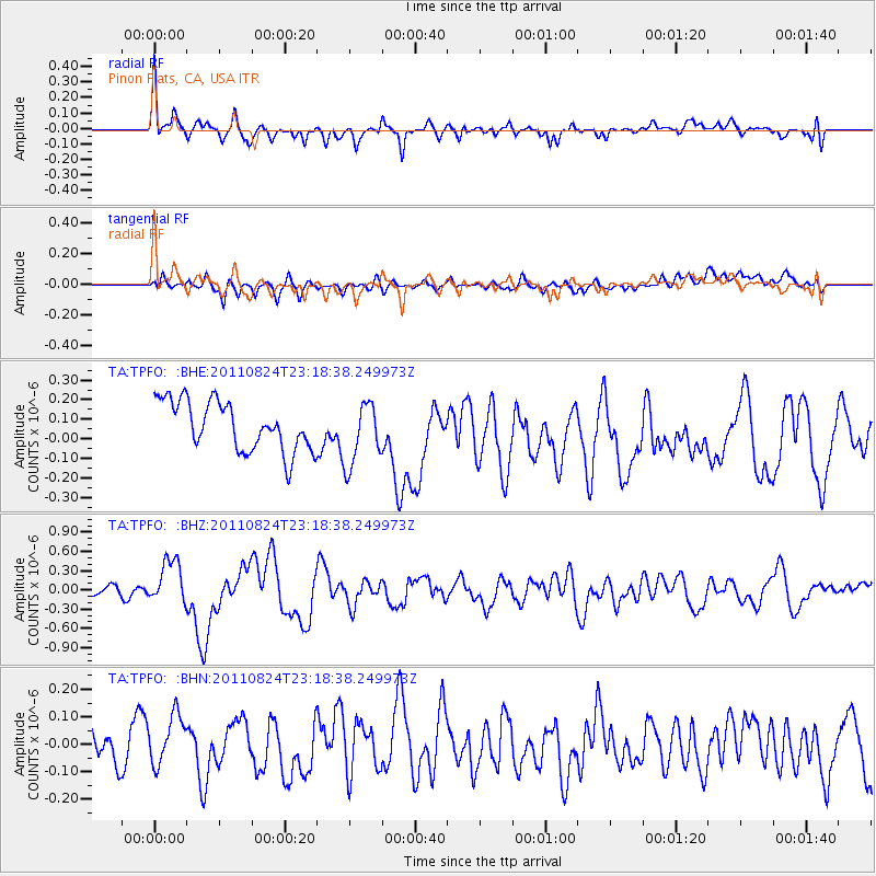
TPFO Pinon Flats, CA, USA - Earthquake Result Viewer
*The percent match for this event was below the threshold and hence no stack was calculated.
| Earthquake location: |
Vanuatu Islands |
| Earthquake latitude/longitude: |
-18.2/167.7 |
| Earthquake time(UTC): |
2011/08/24 (236) 23:06:17 GMT |
| Earthquake Depth: |
13 km |
| Earthquake Magnitude: |
5.7 MB, 6.0 MS, 6.2 MW, 6.1 MW |
| Earthquake Catalog/Contributor: |
WHDF/NEIC |
|
| Network: |
TA USArray Transportable Network (new EarthScope stations) |
| Station: |
TPFO Pinon Flats, CA, USA |
| Lat/Lon: |
33.61 N/116.45 W |
| Elevation: |
1275 m |
|
| Distance: |
88.6 deg |
| Az: |
54.034 deg |
| Baz: |
247.238 deg |
| Ray Param: |
$rayparam |
*The percent match for this event was below the threshold and hence was not used in the summary stack. |
|
| Radial Match: |
56.805145 % |
| Radial Bump: |
400 |
| Transverse Match: |
46.00737 % |
| Transverse Bump: |
400 |
| SOD ConfigId: |
414626 |
| Insert Time: |
2012-01-13 09:04:42.731 +0000 |
| GWidth: |
2.5 |
| Max Bumps: |
400 |
| Tol: |
0.001 |
|
Signal To Noise
| Channel | StoN | STA | LTA |
| TA:TPFO: :BHZ:20110824T23:18:38.249973Z | 5.0726705 | 3.4232175E-7 | 6.748354E-8 |
| TA:TPFO: :BHN:20110824T23:18:38.249973Z | 1.4566059 | 9.7858575E-8 | 6.7182604E-8 |
| TA:TPFO: :BHE:20110824T23:18:38.249973Z | 1.2859557 | 1.6097307E-7 | 1.2517778E-7 |
| Arrivals |
| Ps | |
| PpPs | |
| PsPs/PpSs | |


