You are here: Home > Network List > UW - Pacific Northwest Regional Seismic Network Stations List
> Station MRBL Marblemount, WA, USA > Earthquake Result Viewer
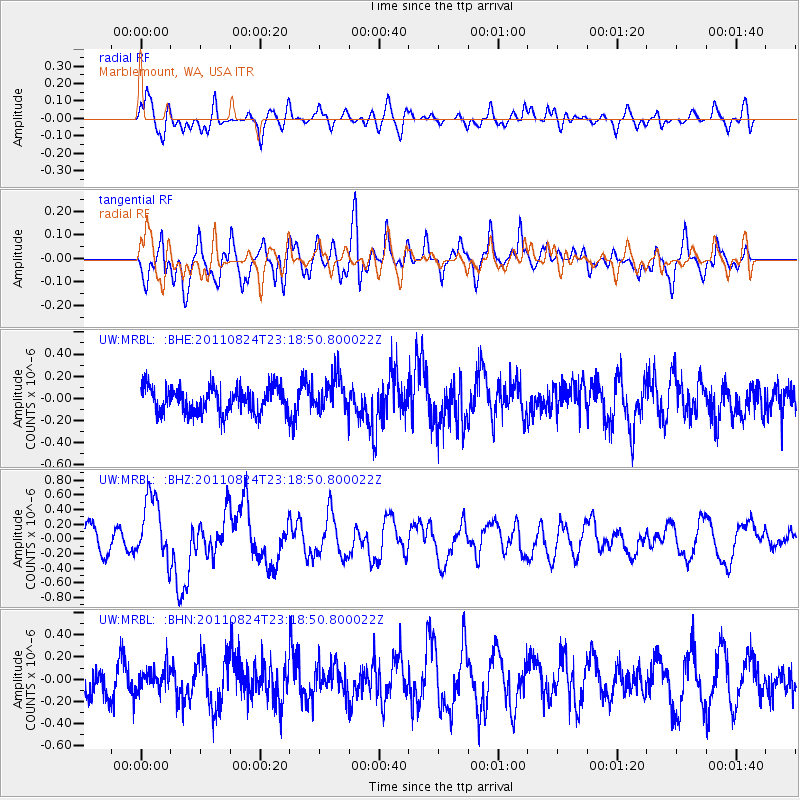
MRBL Marblemount, WA, USA - Earthquake Result Viewer
*The percent match for this event was below the threshold and hence no stack was calculated.
| Earthquake location: |
Vanuatu Islands |
| Earthquake latitude/longitude: |
-18.2/167.7 |
| Earthquake time(UTC): |
2011/08/24 (236) 23:06:17 GMT |
| Earthquake Depth: |
13 km |
| Earthquake Magnitude: |
5.7 MB, 6.0 MS, 6.2 MW, 6.1 MW |
| Earthquake Catalog/Contributor: |
WHDF/NEIC |
|
| Network: |
UW Pacific Northwest Regional Seismic Network |
| Station: |
MRBL Marblemount, WA, USA |
| Lat/Lon: |
48.52 N/121.48 W |
| Elevation: |
75 m |
|
| Distance: |
91.3 deg |
| Az: |
38.904 deg |
| Baz: |
243.913 deg |
| Ray Param: |
$rayparam |
*The percent match for this event was below the threshold and hence was not used in the summary stack. |
|
| Radial Match: |
63.59303 % |
| Radial Bump: |
400 |
| Transverse Match: |
73.88659 % |
| Transverse Bump: |
400 |
| SOD ConfigId: |
414626 |
| Insert Time: |
2012-01-13 09:06:09.551 +0000 |
| GWidth: |
2.5 |
| Max Bumps: |
400 |
| Tol: |
0.001 |
|
Signal To Noise
| Channel | StoN | STA | LTA |
| UW:MRBL: :BHZ:20110824T23:18:50.800022Z | 3.2974107 | 4.3710452E-7 | 1.3255993E-7 |
| UW:MRBL: :BHN:20110824T23:18:50.800022Z | 0.74108917 | 9.57952E-8 | 1.2926272E-7 |
| UW:MRBL: :BHE:20110824T23:18:50.800022Z | 1.3399433 | 1.5369677E-7 | 1.1470394E-7 |
| Arrivals |
| Ps | |
| PpPs | |
| PsPs/PpSs | |


