You are here: Home > Network List > TA - USArray Transportable Network (new EarthScope stations) Stations List
> Station 109C Camp Elliot, Mirimar, CA, USA > Earthquake Result Viewer
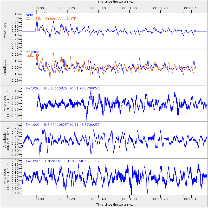
109C Camp Elliot, Mirimar, CA, USA - Earthquake Result Viewer
*The percent match for this event was below the threshold and hence no stack was calculated.
| Earthquake location: |
Vanuatu Islands |
| Earthquake latitude/longitude: |
-13.6/167.0 |
| Earthquake time(UTC): |
2011/08/25 (237) 10:39:58 GMT |
| Earthquake Depth: |
159 km |
| Earthquake Magnitude: |
5.6 MB, 5.9 MW, 5.9 MW |
| Earthquake Catalog/Contributor: |
WHDF/NEIC |
|
| Network: |
TA USArray Transportable Network (new EarthScope stations) |
| Station: |
109C Camp Elliot, Mirimar, CA, USA |
| Lat/Lon: |
32.89 N/117.11 W |
| Elevation: |
150 m |
|
| Distance: |
85.8 deg |
| Az: |
54.907 deg |
| Baz: |
251.007 deg |
| Ray Param: |
$rayparam |
*The percent match for this event was below the threshold and hence was not used in the summary stack. |
|
| Radial Match: |
70.48712 % |
| Radial Bump: |
400 |
| Transverse Match: |
52.89739 % |
| Transverse Bump: |
400 |
| SOD ConfigId: |
414626 |
| Insert Time: |
2012-01-13 09:32:32.982 +0000 |
| GWidth: |
2.5 |
| Max Bumps: |
400 |
| Tol: |
0.001 |
|
Signal To Noise
| Channel | StoN | STA | LTA |
| TA:109C: :BHZ:20110825T10:51:48.570005Z | 2.779926 | 3.7704388E-7 | 1.356309E-7 |
| TA:109C: :BHN:20110825T10:51:48.570005Z | 0.8357573 | 8.7260716E-8 | 1.0440915E-7 |
| TA:109C: :BHE:20110825T10:51:48.570005Z | 2.231856 | 2.0086466E-7 | 8.9998935E-8 |
| Arrivals |
| Ps | |
| PpPs | |
| PsPs/PpSs | |


