You are here: Home > Network List > TA - USArray Transportable Network (new EarthScope stations) Stations List
> Station G03D McMinnville, OR, USA > Earthquake Result Viewer
G03D McMinnville, OR, USA - Earthquake Result Viewer
*The percent match for this event was below the threshold and hence no stack was calculated.
| Earthquake location: |
Vanuatu Islands |
| Earthquake latitude/longitude: |
-13.6/167.0 |
| Earthquake time(UTC): |
2011/08/25 (237) 10:39:58 GMT |
| Earthquake Depth: |
159 km |
| Earthquake Magnitude: |
5.6 MB, 5.9 MW, 5.9 MW |
| Earthquake Catalog/Contributor: |
WHDF/NEIC |
|
| Network: |
TA USArray Transportable Network (new EarthScope stations) |
| Station: |
G03D McMinnville, OR, USA |
| Lat/Lon: |
45.21 N/123.26 W |
| Elevation: |
222 m |
|
| Distance: |
85.8 deg |
| Az: |
41.675 deg |
| Baz: |
246.148 deg |
| Ray Param: |
$rayparam |
*The percent match for this event was below the threshold and hence was not used in the summary stack. |
|
| Radial Match: |
62.056385 % |
| Radial Bump: |
400 |
| Transverse Match: |
44.527752 % |
| Transverse Bump: |
400 |
| SOD ConfigId: |
414626 |
| Insert Time: |
2012-01-13 09:34:26.566 +0000 |
| GWidth: |
2.5 |
| Max Bumps: |
400 |
| Tol: |
0.001 |
|
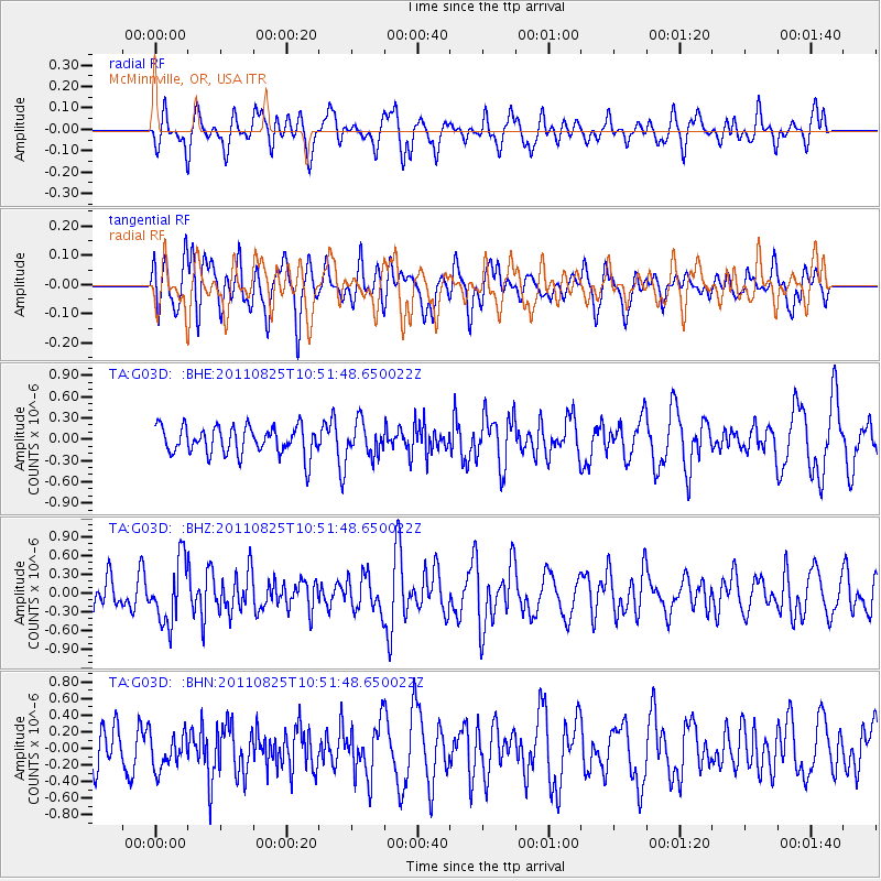
Signal To Noise
| Channel | StoN | STA | LTA |
| TA:G03D: :BHZ:20110825T10:51:48.650022Z | 2.351147 | 4.9665294E-7 | 2.1123859E-7 |
| TA:G03D: :BHN:20110825T10:51:48.650022Z | 0.97341037 | 2.154133E-7 | 2.2129751E-7 |
| TA:G03D: :BHE:20110825T10:51:48.650022Z | 1.1758007 | 2.3174898E-7 | 1.9709887E-7 |
| Arrivals |
| Ps | |
| PpPs | |
| PsPs/PpSs | |


