You are here: Home > Network List > UW - Pacific Northwest Regional Seismic Network Stations List
> Station MRBL Marblemount, WA, USA > Earthquake Result Viewer
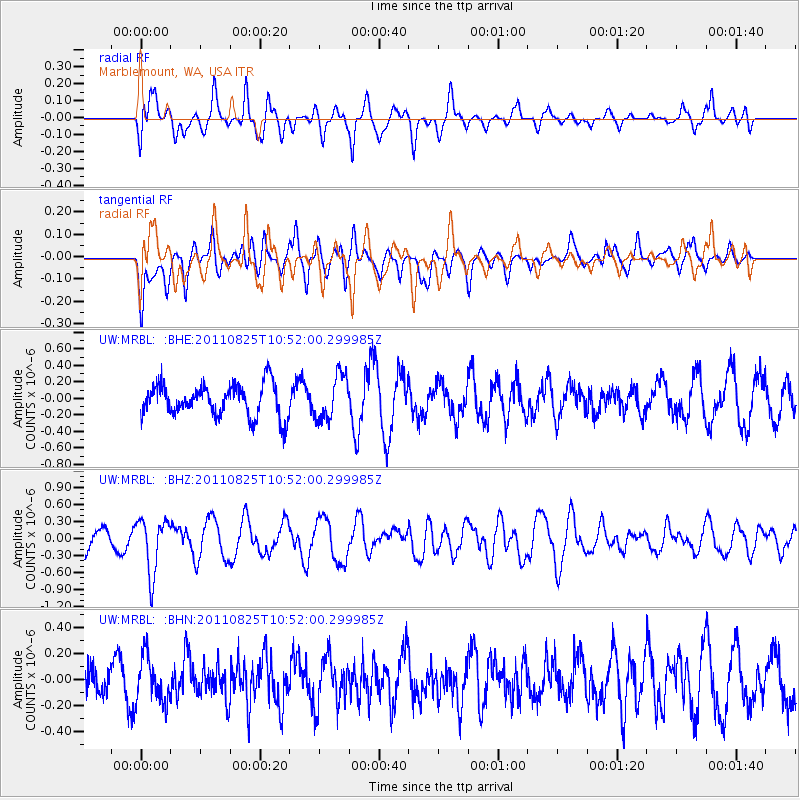
MRBL Marblemount, WA, USA - Earthquake Result Viewer
*The percent match for this event was below the threshold and hence no stack was calculated.
| Earthquake location: |
Vanuatu Islands |
| Earthquake latitude/longitude: |
-13.6/167.0 |
| Earthquake time(UTC): |
2011/08/25 (237) 10:39:58 GMT |
| Earthquake Depth: |
159 km |
| Earthquake Magnitude: |
5.6 MB, 5.9 MW, 5.9 MW |
| Earthquake Catalog/Contributor: |
WHDF/NEIC |
|
| Network: |
UW Pacific Northwest Regional Seismic Network |
| Station: |
MRBL Marblemount, WA, USA |
| Lat/Lon: |
48.52 N/121.48 W |
| Elevation: |
75 m |
|
| Distance: |
88.3 deg |
| Az: |
39.115 deg |
| Baz: |
247.311 deg |
| Ray Param: |
$rayparam |
*The percent match for this event was below the threshold and hence was not used in the summary stack. |
|
| Radial Match: |
47.107285 % |
| Radial Bump: |
400 |
| Transverse Match: |
50.21455 % |
| Transverse Bump: |
400 |
| SOD ConfigId: |
414626 |
| Insert Time: |
2012-01-13 09:38:02.189 +0000 |
| GWidth: |
2.5 |
| Max Bumps: |
400 |
| Tol: |
0.001 |
|
Signal To Noise
| Channel | StoN | STA | LTA |
| UW:MRBL: :BHZ:20110825T10:52:00.299985Z | 3.146119 | 4.8327354E-7 | 1.5360942E-7 |
| UW:MRBL: :BHN:20110825T10:52:00.299985Z | 1.0152887 | 1.6776278E-7 | 1.6523651E-7 |
| UW:MRBL: :BHE:20110825T10:52:00.299985Z | 1.3620361 | 2.6506544E-7 | 1.946097E-7 |
| Arrivals |
| Ps | |
| PpPs | |
| PsPs/PpSs | |


