You are here: Home > Network List > AZ - ANZA Regional Network Stations List
> Station SMER AZ.SMER > Earthquake Result Viewer
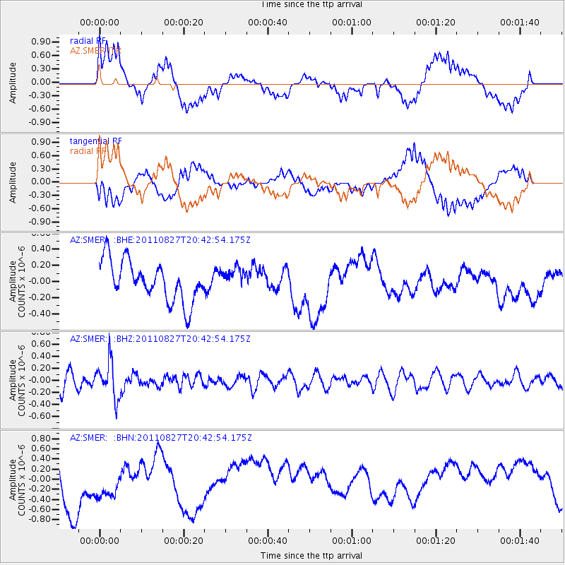
SMER AZ.SMER - Earthquake Result Viewer
*The percent match for this event was below the threshold and hence no stack was calculated.
| Earthquake location: |
South Of Fiji Islands |
| Earthquake latitude/longitude: |
-24.6/179.9 |
| Earthquake time(UTC): |
2011/08/27 (239) 20:31:53 GMT |
| Earthquake Depth: |
509 km |
| Earthquake Magnitude: |
5.7 MW, 5.1 MB |
| Earthquake Catalog/Contributor: |
WHDF/NEIC |
|
| Network: |
AZ ANZA Regional Network |
| Station: |
SMER AZ.SMER |
| Lat/Lon: |
33.46 N/117.17 W |
| Elevation: |
355 m |
|
| Distance: |
83.1 deg |
| Az: |
48.557 deg |
| Baz: |
234.715 deg |
| Ray Param: |
$rayparam |
*The percent match for this event was below the threshold and hence was not used in the summary stack. |
|
| Radial Match: |
48.906208 % |
| Radial Bump: |
400 |
| Transverse Match: |
53.240677 % |
| Transverse Bump: |
400 |
| SOD ConfigId: |
414626 |
| Insert Time: |
2012-01-18 05:35:23.274 +0000 |
| GWidth: |
2.5 |
| Max Bumps: |
400 |
| Tol: |
0.001 |
|
Signal To Noise
| Channel | StoN | STA | LTA |
| AZ:SMER: :BHZ:20110827T20:42:54.175Z | 1.7327558 | 3.1611316E-7 | 1.8243375E-7 |
| AZ:SMER: :BHN:20110827T20:42:54.175Z | 0.77814126 | 3.2692577E-7 | 4.2013676E-7 |
| AZ:SMER: :BHE:20110827T20:42:54.175Z | 0.5227599 | 1.295687E-7 | 2.4785507E-7 |
| Arrivals |
| Ps | |
| PpPs | |
| PsPs/PpSs | |


