You are here: Home > Network List > CI - Caltech Regional Seismic Network Stations List
> Station SWS Sam W. Stewart, Westmorland, CA, USA > Earthquake Result Viewer
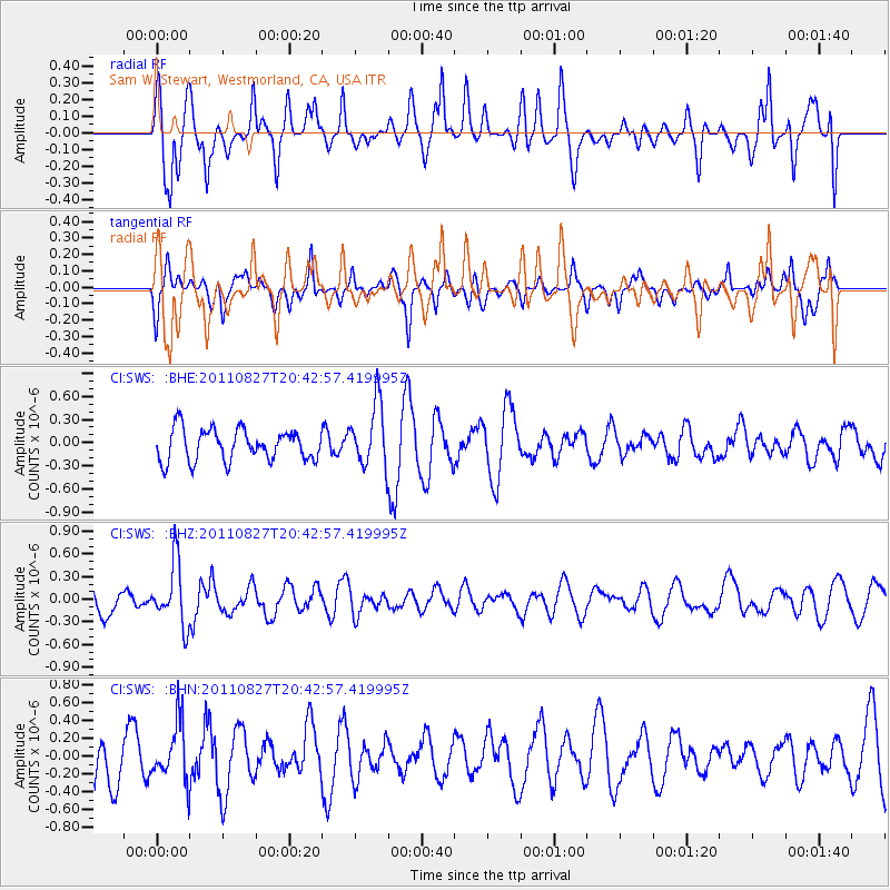
SWS Sam W. Stewart, Westmorland, CA, USA - Earthquake Result Viewer
*The percent match for this event was below the threshold and hence no stack was calculated.
| Earthquake location: |
South Of Fiji Islands |
| Earthquake latitude/longitude: |
-24.6/179.9 |
| Earthquake time(UTC): |
2011/08/27 (239) 20:31:53 GMT |
| Earthquake Depth: |
509 km |
| Earthquake Magnitude: |
5.7 MW, 5.1 MB |
| Earthquake Catalog/Contributor: |
WHDF/NEIC |
|
| Network: |
CI Caltech Regional Seismic Network |
| Station: |
SWS Sam W. Stewart, Westmorland, CA, USA |
| Lat/Lon: |
32.94 N/115.80 W |
| Elevation: |
140 m |
|
| Distance: |
83.8 deg |
| Az: |
49.646 deg |
| Baz: |
235.588 deg |
| Ray Param: |
$rayparam |
*The percent match for this event was below the threshold and hence was not used in the summary stack. |
|
| Radial Match: |
61.96006 % |
| Radial Bump: |
339 |
| Transverse Match: |
49.819927 % |
| Transverse Bump: |
337 |
| SOD ConfigId: |
414626 |
| Insert Time: |
2012-01-18 05:37:17.345 +0000 |
| GWidth: |
2.5 |
| Max Bumps: |
400 |
| Tol: |
0.001 |
|
Signal To Noise
| Channel | StoN | STA | LTA |
| CI:SWS: :BHZ:20110827T20:42:57.419995Z | 2.7731166 | 4.0832504E-7 | 1.472441E-7 |
| CI:SWS: :BHN:20110827T20:42:57.419995Z | 0.83276296 | 3.2232344E-7 | 3.8705303E-7 |
| CI:SWS: :BHE:20110827T20:42:57.419995Z | 2.042943 | 4.1378783E-7 | 2.0254497E-7 |
| Arrivals |
| Ps | |
| PpPs | |
| PsPs/PpSs | |


