You are here: Home > Network List > TA - USArray Transportable Network (new EarthScope stations) Stations List
> Station O02D Mt. Diablo Meridian, CA, USA > Earthquake Result Viewer
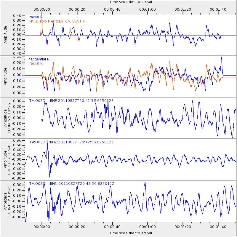
O02D Mt. Diablo Meridian, CA, USA - Earthquake Result Viewer
*The percent match for this event was below the threshold and hence no stack was calculated.
| Earthquake location: |
South Of Fiji Islands |
| Earthquake latitude/longitude: |
-24.6/179.9 |
| Earthquake time(UTC): |
2011/08/27 (239) 20:31:53 GMT |
| Earthquake Depth: |
509 km |
| Earthquake Magnitude: |
5.7 MW, 5.1 MB |
| Earthquake Catalog/Contributor: |
WHDF/NEIC |
|
| Network: |
TA USArray Transportable Network (new EarthScope stations) |
| Station: |
O02D Mt. Diablo Meridian, CA, USA |
| Lat/Lon: |
40.18 N/122.79 W |
| Elevation: |
965 m |
|
| Distance: |
83.6 deg |
| Az: |
40.442 deg |
| Baz: |
230.418 deg |
| Ray Param: |
$rayparam |
*The percent match for this event was below the threshold and hence was not used in the summary stack. |
|
| Radial Match: |
57.274544 % |
| Radial Bump: |
400 |
| Transverse Match: |
51.55925 % |
| Transverse Bump: |
400 |
| SOD ConfigId: |
414626 |
| Insert Time: |
2012-01-18 05:42:28.569 +0000 |
| GWidth: |
2.5 |
| Max Bumps: |
400 |
| Tol: |
0.001 |
|
Signal To Noise
| Channel | StoN | STA | LTA |
| TA:O02D: :BHZ:20110827T20:42:56.625012Z | 2.4185667 | 3.6850315E-7 | 1.5236427E-7 |
| TA:O02D: :BHN:20110827T20:42:56.625012Z | 1.1101662 | 2.1506501E-7 | 1.9372327E-7 |
| TA:O02D: :BHE:20110827T20:42:56.625012Z | 1.0206473 | 1.1818533E-7 | 1.1579449E-7 |
| Arrivals |
| Ps | |
| PpPs | |
| PsPs/PpSs | |


