You are here: Home > Network List > CI - Caltech Regional Seismic Network Stations List
> Station LRL Laurel Mtn Radio Fac, Ridgecrest, CA, USA > Earthquake Result Viewer
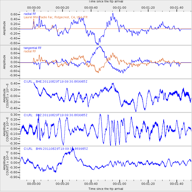
LRL Laurel Mtn Radio Fac, Ridgecrest, CA, USA - Earthquake Result Viewer
*The percent match for this event was below the threshold and hence no stack was calculated.
| Earthquake location: |
Vanuatu Islands |
| Earthquake latitude/longitude: |
-16.4/167.9 |
| Earthquake time(UTC): |
2011/08/29 (241) 18:57:39 GMT |
| Earthquake Depth: |
202 km |
| Earthquake Magnitude: |
5.5 MB, 5.6 MW |
| Earthquake Catalog/Contributor: |
WHDF/NEIC |
|
| Network: |
CI Caltech Regional Seismic Network |
| Station: |
LRL Laurel Mtn Radio Fac, Ridgecrest, CA, USA |
| Lat/Lon: |
35.48 N/117.68 W |
| Elevation: |
1340 m |
|
| Distance: |
87.2 deg |
| Az: |
51.903 deg |
| Baz: |
247.778 deg |
| Ray Param: |
$rayparam |
*The percent match for this event was below the threshold and hence was not used in the summary stack. |
|
| Radial Match: |
26.550295 % |
| Radial Bump: |
400 |
| Transverse Match: |
35.101017 % |
| Transverse Bump: |
400 |
| SOD ConfigId: |
414626 |
| Insert Time: |
2012-01-18 05:51:11.048 +0000 |
| GWidth: |
2.5 |
| Max Bumps: |
400 |
| Tol: |
0.001 |
|
Signal To Noise
| Channel | StoN | STA | LTA |
| CI:LRL: :BHZ:20110829T19:09:30.869985Z | 1.8391868 | 1.2940038E-7 | 7.035739E-8 |
| CI:LRL: :BHN:20110829T19:09:30.869985Z | 3.1573966 | 3.399298E-7 | 1.0766142E-7 |
| CI:LRL: :BHE:20110829T19:09:30.869985Z | 1.1768898 | 1.6193299E-7 | 1.3759401E-7 |
| Arrivals |
| Ps | |
| PpPs | |
| PsPs/PpSs | |


